IMAGES TAKEN NEAR TO
Bonser Close, NOTTINGHAM, NG4 1DP
Introduction
This page details the photographs taken nearby to Bonser Close, NG4 1DP by members of the Geograph project.
The Geograph project started in 2005 with the aim of publishing, organising and preserving representative images for every square kilometre of Great Britain, Ireland and the Isle of Man.

There are currently over 7.5m images from over14,400 individuals and you can help contribute to the project by visiting https://www.geograph.org.uk
Image Map
Images are licensed for reuse under creativecommons.org/licenses/by-sa/2.0
Notes
- Clicking on the map will re-center to the selected point.
- The higher the marker number, the further away the image location is from the centre of the postcode.
Image Listing (42 Images Found)
Images are licensed for reuse under creativecommons.org/licenses/by-sa/2.0
Image
Details
Distance
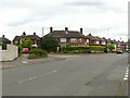
1
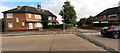
Houses at junction in Southdale Drive
Image: © Roger Templeman
Taken: 26 Sep 2022
0.12 miles
2
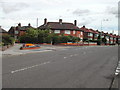
Junction Southdale Drive/ Oakdale Road, Carlton, Nottingham
Image: © Tom Courtney
Taken: 26 Aug 2005
0.13 miles
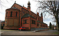
3
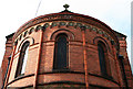
St Paul's, chancel apse exterior
The church was designed by W. A. Coombs.
An elderly gentleman who approached me as I started to photograph the building told me that he was just finishing-off a book of the history of the church and that it was built for the 4th Earl of Carnarvon and it sat unfinished for six years after the money ran-out. This is somewhat confirmed by its listing (Grade II) description which dates it as 1885 and 1891.
A plaque on the outside of the chancel confirms the patronage Image
Image: © David Lally
Taken: 6 Mar 2010
0.13 miles
4
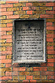
Dedication plaque on St Paul's
On the outside wall of the chancel apse.
Image: © David Lally
Taken: 6 Mar 2010
0.13 miles
5
Junction Southdale Drive/ Oakdale Road, Carlton, Nottingham
Recreating this original 'First' for square SK6141 https://www.geograph.org.uk/photo/43303 which turns out to be in the neighbouring square SK6140 . The small flower beds have been planted with lower maintenance plants, and there is a new wall on the left hand edge of the picture. The original view originally incorrectly referred to 'Southdale Road' rather than 'Southdale Drive'.
Image: © Alan Murray-Rust
Taken: 23 May 2021
0.14 miles
6
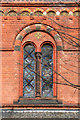
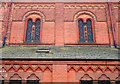
Window detail, St Pauls
Romanesque church finished in 1891 designed by W. A. Coombs. See also Image
Image: © David Lally
Taken: 6 Mar 2010
0.14 miles
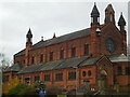
7
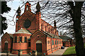
St Paul's Carlton-in-the-Willows
From the north west.
The plaque visible in the chancel apse explains its dedication Image
Image: © David Lally
Taken: 6 Mar 2010
0.14 miles
9
St Paul's, Carlton-in-the-Willows
The church was designed by W. A. Coombs.
An elderly gentleman who approached me as I started to photograph the building told me that he was just finishing-off a book of the history of the church and that it was built for the 4th Earl of Carnarvon and it sat unfinished for six years after the money ran-out. This is somewhat confirmed by its listing (Grade II) description which dates it as 1885 and 1891.
A plaque on the outside of the chancel confirms the patronage Image
Image: © David Lally
Taken: 6 Mar 2010
0.14 miles
10
St Paul's nave exterior
The church was designed by W. A. Coombs.
An elderly gentleman who approached me as I started to photograph the building told me that he was just finishing-off a book of the history of the church and that it was built for the 4th Earl of Carnarvon and it sat unfinished for six years after the money ran-out. This is somewhat confirmed by its listing (Grade II) description which dates it as 1885 and 1891.
A plaque on the outside of the chancel confirms the patronage Image
Image: © David Lally
Taken: 6 Mar 2010
0.14 miles