IMAGES TAKEN NEAR TO
Oakdale Road, NOTTINGHAM, NG4 1DG
Introduction
This page details the photographs taken nearby to Oakdale Road, NG4 1DG by members of the Geograph project.
The Geograph project started in 2005 with the aim of publishing, organising and preserving representative images for every square kilometre of Great Britain, Ireland and the Isle of Man.

There are currently over 7.5m images from over14,400 individuals and you can help contribute to the project by visiting https://www.geograph.org.uk
Image Map
Images are licensed for reuse under creativecommons.org/licenses/by-sa/2.0
Notes
- Clicking on the map will re-center to the selected point.
- The higher the marker number, the further away the image location is from the centre of the postcode.
Image Listing (27 Images Found)
Images are licensed for reuse under creativecommons.org/licenses/by-sa/2.0
Image
Details
Distance
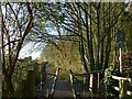
4
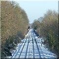
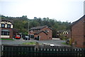
Netherfield Junction
A snowy view from the footbridge at the bottom of Douglas Avenue.
Image: © Alan Murray-Rust
Taken: 25 Jan 2021
0.13 miles
6
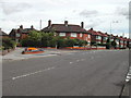
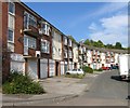
Junction Southdale Drive/ Oakdale Road, Carlton, Nottingham
Image: © Tom Courtney
Taken: 26 Aug 2005
0.18 miles
7
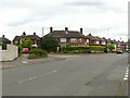
Junction Southdale Drive/ Oakdale Road, Carlton, Nottingham
Recreating this original 'First' for square SK6141 https://www.geograph.org.uk/photo/43303 which turns out to be in the neighbouring square SK6140 . The small flower beds have been planted with lower maintenance plants, and there is a new wall on the left hand edge of the picture. The original view originally incorrectly referred to 'Southdale Road' rather than 'Southdale Drive'.
Image: © Alan Murray-Rust
Taken: 23 May 2021
0.18 miles
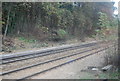
8
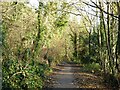
Midland Wood Cycle Route
The wood doesn't have a name on any OS mapping, and the name may have been invented when the path was improved as a cycleway in recent times. The path follows a narrow strip between the railway on the right and the steep scarp on the left, colonised by traditional broadleaf woodland and representing the edge of the River Trent's alluvial plain.
Image: © Alan Murray-Rust
Taken: 17 Dec 2020
0.19 miles
9
Midland Wood Cycle Route
The wood doesn't have a name on any OS mapping, and the name may have been invented when the path was improved as a cycleway in recent times. The path follows a narrow strip between the railway on the left and the steep scarp on the right, colonised by traditional broadleaf woodland and representing the edge of the River Trent's alluvial plain.
Image: © Alan Murray-Rust
Taken: 17 Dec 2020
0.19 miles
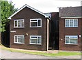
10
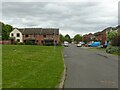
Hotspur Drive, Netherfield
Late 20th century housing development on former industrial land.
Image: © Alan Murray-Rust
Taken: 23 May 2021
0.20 miles