IMAGES TAKEN NEAR TO
Oakdale Road, NOTTINGHAM, NG4 1AH
Introduction
This page details the photographs taken nearby to Oakdale Road, NG4 1AH by members of the Geograph project.
The Geograph project started in 2005 with the aim of publishing, organising and preserving representative images for every square kilometre of Great Britain, Ireland and the Isle of Man.

There are currently over 7.5m images from over14,400 individuals and you can help contribute to the project by visiting https://www.geograph.org.uk
Image Map
Images are licensed for reuse under creativecommons.org/licenses/by-sa/2.0
Notes
- Clicking on the map will re-center to the selected point.
- The higher the marker number, the further away the image location is from the centre of the postcode.
Image Listing (31 Images Found)
Images are licensed for reuse under creativecommons.org/licenses/by-sa/2.0
Image
Details
Distance
1
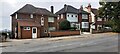
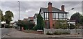
Nos. 192, 190 and 188 Oakdale Road
Ordnance Survey documents indicate that a benchmark levelled at 77.730m above Newlyn Datum was verified in 1962 on a gatepost in the wall fronting the left hand house. The wall appears to have been replaced and the 'gateway' widened in recent times
Image: © Roger Templeman
Taken: 26 Sep 2022
0.00 miles
2
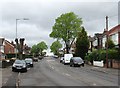
Bakersfield: Oakdale Road on a grey May morning
The districts of Arnold and Carlton, though physically part of the city, are in the Borough of Gedling. The city boundary (shown in Alan Murray-Rust's Image]) is just up the road.
Image: © John Sutton
Taken: 10 May 2012
0.03 miles
3
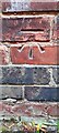
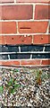
Benchmark on the chimney breast on west face of #167 Oakdale Road
Ordnance Survey cut mark benchmark levelled at 81.278m above Newlyn Datum verified 1962
Image: © Roger Templeman
Taken: 26 Sep 2022
0.09 miles
4
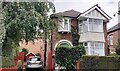
#167 Oakdale Road
There is an Ordnance Survey benchmark Image on the chimney breast on the left hand side of the house, where a car is parked
Image: © Roger Templeman
Taken: 26 Sep 2022
0.10 miles
5
Houses on Oakdale Road at Poplar Close junction
There is an Ordnance Survey benchmark Image on the chimney breast of the nearest house
Image: © Roger Templeman
Taken: 26 Sep 2022
0.10 miles
6
Benchmark on chimney breast of #216 Oakdale Road
Ordnance Survey cut mark benchmark levelled at 75.801m above Newlyn Datum verified 1962
Image: © Roger Templeman
Taken: 26 Sep 2022
0.10 miles
7
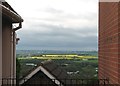
Bakersfield: view from Oakdale Road
The gaps between the houses on Oakdale Road give glimpses over Colwick Country Park and the wide Trent Valley to the South Nottinghamshire wolds in the distance. In May there is a lot of yellow oilseed rape to be seen.
Image: © John Sutton
Taken: 10 May 2012
0.12 miles
8
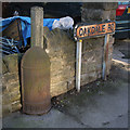
Boundary marker
The City of Nottingham used these cast iron boundary markers from the end of the nineteenth century. A number still remain in place, mainly better looked after than this example.
Image: © Alan Murray-Rust
Taken: 14 Jan 2007
0.13 miles
9
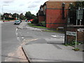
Junction Douglas Ave/ Oakdale Road, Carlton, Nottingham
Image: © Tom Courtney
Taken: 26 Aug 2005
0.17 miles
10
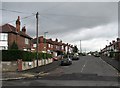
Bakersfield: Dovedale Road
The city expanded into this part of the eastern hills in the 1930s.
Image: © John Sutton
Taken: 10 May 2012
0.17 miles