IMAGES TAKEN NEAR TO
Porchester Road, NOTTINGHAM, NG3 6JG
Introduction
This page details the photographs taken nearby to Porchester Road, NG3 6JG by members of the Geograph project.
The Geograph project started in 2005 with the aim of publishing, organising and preserving representative images for every square kilometre of Great Britain, Ireland and the Isle of Man.

There are currently over 7.5m images from over14,400 individuals and you can help contribute to the project by visiting https://www.geograph.org.uk
Image Map
Images are licensed for reuse under creativecommons.org/licenses/by-sa/2.0
Notes
- Clicking on the map will re-center to the selected point.
- The higher the marker number, the further away the image location is from the centre of the postcode.
Image Listing (32 Images Found)
Images are licensed for reuse under creativecommons.org/licenses/by-sa/2.0
Image
Details
Distance
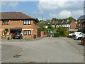
1
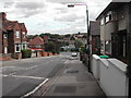
Radstock Road
Looking down to the junction with Porchester Road, Nottingham
Image: © Tom Courtney
Taken: 26 Aug 2005
0.06 miles
2
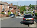
Radstock Road, Thorneywood
Recreating this 'First' for the square https://www.geograph.org.uk/photo/43309
Image: © Alan Murray-Rust
Taken: 27 May 2021
0.06 miles
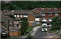
3
Marmion Road (north end)
The road has been blocked to prevent its use as a rat run, but the presence of different styles of post show that in practice the barrier has been breached from time to time.
Image: © Alan Murray-Rust
Taken: 27 Apr 2008
0.09 miles
4
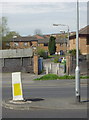
Former footbridge location
The dark engineering brick wall formerly marked the edge of the area of Thorneywood Station. This lay in a cutting well below the road and was crossed by a lattice metal footbridge which lasted for years after the station and railway closed. The cutting was for a long time a Post Office Telephones maintenance depot, but has since been filled in converted for housing use.
Image: © Alan Murray-Rust
Taken: 27 Apr 2008
0.11 miles
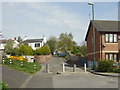
5
Porter's Walk
On the site of the footbridge across the railway at Thorneywood Station. The housing is built on several metres of infill on top of the old railway level.
Image: © Alan Murray-Rust
Taken: 27 May 2021
0.12 miles
6
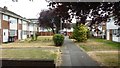
Honeywood Court
Pleasant little group of houses between Honeywood Drive and Galena Drive
Image: © David Lally
Taken: 13 Jul 2018
0.13 miles
7
Bus in the Brickyard Estate, Thorneywood – 1986
In the run-up to the deregulation of bus services in October 1986, City of Nottingham Transport introduced a series of ‘Accessline’ services using small buses to reach areas that could not be served by full size buses. The idea was that these areas would not be attractive to possible competitors after deregulation and that passengers would be attracted to use these localised services rather than walk to main roads. These services were never economically viable and in most cases, including this route, services were withdrawn soon after deregulation and have not been replaced since.
Image: © Alan Murray-Rust
Taken: 1 May 1986
0.15 miles
8
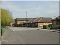
Marmion Road (south end)
The modern housing has been built on the site of the old Thorneywood Station.
Image: © Alan Murray-Rust
Taken: 27 Apr 2008
0.15 miles
9
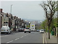
The view down Carlton Road
Carlton Road is a fairly long continuous drag up from the City Centre. The location of Nottingham at the edge of the Trent Valley, which stretches into the distance, can be well seen.
Image: © Alan Murray-Rust
Taken: 27 Apr 2008
0.15 miles
10

Big brick ball
You will need a large brickbat to hit it! Outside the Brickyard Community Centre, see http://www.geograph.org.uk/photo/4963378
Image: © Alan Murray-Rust
Taken: 23 May 2016
0.15 miles