IMAGES TAKEN NEAR TO
St. James Court, NOTTINGHAM, NG3 6GH
Introduction
This page details the photographs taken nearby to St. James Court, NG3 6GH by members of the Geograph project.
The Geograph project started in 2005 with the aim of publishing, organising and preserving representative images for every square kilometre of Great Britain, Ireland and the Isle of Man.

There are currently over 7.5m images from over14,400 individuals and you can help contribute to the project by visiting https://www.geograph.org.uk
Image Map
Images are licensed for reuse under creativecommons.org/licenses/by-sa/2.0
Notes
- Clicking on the map will re-center to the selected point.
- The higher the marker number, the further away the image location is from the centre of the postcode.
Image Listing (17 Images Found)
Images are licensed for reuse under creativecommons.org/licenses/by-sa/2.0
Image
Details
Distance
1
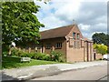
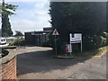
Church of St James, Porchester, Gedling
The church was created from the former Marshall Hill Farm in 1935, utilising a former threshing barn. This forms the further part of the church, to which the main nave, nearer the camera, was added in 1955.
Image: © Alan Murray-Rust
Taken: 25 May 2021
0.04 miles
2
Newstead Drive, Porchester, Gedling
Part of the inter-war extension of the Porchester Gardens housing area.
Image: © Alan Murray-Rust
Taken: 25 May 2021
0.05 miles
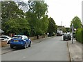
3
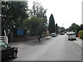
Marshall Hill Drive, Gedling
On the left the entrance to St James Parish Church.
Image: © Tom Courtney
Taken: 18 Aug 2005
0.06 miles
4
Entrance to St James Court
On Marshall Hill Drive
Image: © David Lally
Taken: 12 Jul 2018
0.06 miles
5
Marshall Hill Drive, Gedling
Recreating this 'First' for the square https://www.geograph.org.uk/photo/39363
Image: © Alan Murray-Rust
Taken: 25 May 2021
0.06 miles
6
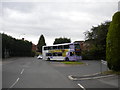
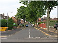
Elmhurst Avenue terminus, Carlton
A 27 from Nottingham city centre using the turning circle to reach the bus stop (next to the enormous hedge on the left) and face the right way to return to the city.
Image: © Richard Vince
Taken: 25 Jun 2011
0.15 miles
7
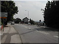
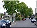
Westdale Lane
at the junction of Cavindish Road, Carlton
Image: © Tom Courtney
Taken: 18 Aug 2005
0.17 miles
8
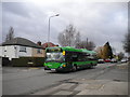
Bus on Westdale Lane West
The 25 travels the length of Westdale Lane between Mapperley and Gedling on its indirect route between Arnold and Nottingham city centre. This one is passing the junction with Holyoake Road on its way to the city, and is, unusually for this route, a single decker.
Image: © Richard Vince
Taken: 21 Jan 2012
0.17 miles
9
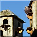
Enjoying the sunshine
Pigeon cotes on Portland Road.
Image: © Alan Murray-Rust
Taken: 12 Jan 2021
0.18 miles