IMAGES TAKEN NEAR TO
Digby Avenue, NOTTINGHAM, NG3 6EA
Introduction
This page details the photographs taken nearby to Digby Avenue, NG3 6EA by members of the Geograph project.
The Geograph project started in 2005 with the aim of publishing, organising and preserving representative images for every square kilometre of Great Britain, Ireland and the Isle of Man.

There are currently over 7.5m images from over14,400 individuals and you can help contribute to the project by visiting https://www.geograph.org.uk
Image Map
Images are licensed for reuse under creativecommons.org/licenses/by-sa/2.0
Notes
- Clicking on the map will re-center to the selected point.
- The higher the marker number, the further away the image location is from the centre of the postcode.
Image Listing (15 Images Found)
Images are licensed for reuse under creativecommons.org/licenses/by-sa/2.0
Image
Details
Distance
1
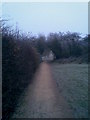
Footpath near Digby Avenue
The footpath that runs along the outside perimeter of Mapperley Golf Course. The area to the south-east of here has been fenced off and left untouched as a small wildlife habitat.
Image: © N Harrison
Taken: 28 Dec 2008
0.05 miles
2
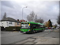
Bus on Westdale Lane West
The 25 travels the length of Westdale Lane between Mapperley and Gedling on its indirect route between Arnold and Nottingham city centre. This one is passing the junction with Holyoake Road on its way to the city, and is, unusually for this route, a single decker.
Image: © Richard Vince
Taken: 21 Jan 2012
0.16 miles
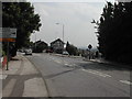
3
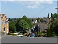
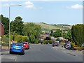
County Road, Gedling
One of the many very steep roads in this area.
Image: © Alan Murray-Rust
Taken: 30 May 2020
0.18 miles

5
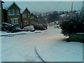
County Road, Gedling
Looking down County Road in the December (2009) snow.
Image: © N Harrison
Taken: 20 Dec 2009
0.19 miles
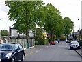
7
Westdale Lane
at the junction of Cavindish Road, Carlton
Image: © Tom Courtney
Taken: 18 Aug 2005
0.22 miles
8
Newstead Drive, Porchester, Gedling
Part of the inter-war extension of the Porchester Gardens housing area.
Image: © Alan Murray-Rust
Taken: 25 May 2021
0.23 miles
9
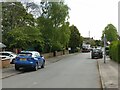
Marshall Hill Drive, Gedling
Recreating this 'First' for the square https://www.geograph.org.uk/photo/39363
Image: © Alan Murray-Rust
Taken: 25 May 2021
0.23 miles
10
Shelford Road, Gedling
One of the many very steep roads in this area, Shelford Road is a main distributor road and bus route. In the distance the slopes of the former Gedling Colliery spoil tip, now part of Gedling Country Park.
Image: © Alan Murray-Rust
Taken: 30 May 2020
0.24 miles