IMAGES TAKEN NEAR TO
Kent Road, NOTTINGHAM, NG3 6BS
Introduction
This page details the photographs taken nearby to Kent Road, NG3 6BS by members of the Geograph project.
The Geograph project started in 2005 with the aim of publishing, organising and preserving representative images for every square kilometre of Great Britain, Ireland and the Isle of Man.

There are currently over 7.5m images from over14,400 individuals and you can help contribute to the project by visiting https://www.geograph.org.uk
Image Map
Images are licensed for reuse under creativecommons.org/licenses/by-sa/2.0
Notes
- Clicking on the map will re-center to the selected point.
- The higher the marker number, the further away the image location is from the centre of the postcode.
Image Listing (7 Images Found)
Images are licensed for reuse under creativecommons.org/licenses/by-sa/2.0
Image
Details
Distance
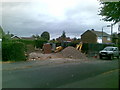
2
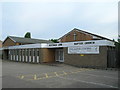
New homes for the elderly
Development on Mapperley Plains at the corner of Hazel Grove.
Image: © Alan Murray-Rust
Taken: 1 Feb 2009
0.19 miles
3
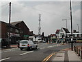
Communications Mast
At the junction of Westdale Lane and Woodborough Road
Image: © Tom Courtney
Taken: 18 Aug 2005
0.21 miles
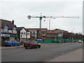
4
Communications Mast
Recreating this 'First' for the square http://www.geograph.org.uk/photo/39364
Image: © Alan Murray-Rust
Taken: 27 May 2021
0.22 miles
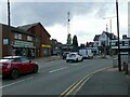
5

Mapperley Plains
On top of the ridge (spot height 127m/416ft), looking towards the corner of Westdale Lane and the shops beyond. The land slopes down sharply either side of Plains Road, to Gedling and the Trent Valley (20m/65ft) to the south east and to Daybrook, Woodthorpe and Arnold to the north east.
Image: © John Sutton
Taken: 23 Jun 2014
0.22 miles
7
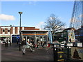
Alfresco Caffe
At the centre of the shopping area on Plains Road.
Image: © Jonathan Thacker
Taken: 7 Dec 2015
0.25 miles