IMAGES TAKEN NEAR TO
Mapperley Plains, NOTTINGHAM, NG3 5RX
Introduction
This page details the photographs taken nearby to Mapperley Plains, NG3 5RX by members of the Geograph project.
The Geograph project started in 2005 with the aim of publishing, organising and preserving representative images for every square kilometre of Great Britain, Ireland and the Isle of Man.

There are currently over 7.5m images from over14,400 individuals and you can help contribute to the project by visiting https://www.geograph.org.uk
Image Map
Images are licensed for reuse under creativecommons.org/licenses/by-sa/2.0
Notes
- Clicking on the map will re-center to the selected point.
- The higher the marker number, the further away the image location is from the centre of the postcode.
Image Listing (16 Images Found)
Images are licensed for reuse under creativecommons.org/licenses/by-sa/2.0
Image
Details
Distance
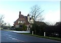
1
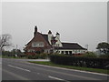
Mapperley Plains, Gedling Borough
The Travellers Rest Inn on the B684
Image: © Tom Courtney
Taken: 15 Apr 2004
0.01 miles
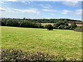
3
The top of Lambley Dumble
The head of one of the series of deep-cut valleys to the north-east of Nottingham.
Image: © Alan Murray-Rust
Taken: 21 Aug 2011
0.11 miles
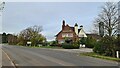
4
The Travellers Rest
Public house & restaurant on Mapperley Plains.
Image: © Graham Hogg
Taken: 8 Nov 2021
0.11 miles
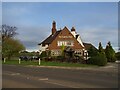
5
Mapperley Plains, Gedling Borough
Recreating this 'First' for the square https://www.geograph.org.uk/photo/32047 . The Travellers Rest has not been subject to the modern trend of changing its name.
Image: © Alan Murray-Rust
Taken: 18 Jan 2023
0.11 miles
6
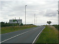
Approach to Woodborough turn
On the B684 out of Nottingham.
Image: © Alan Murray-Rust
Taken: 21 Aug 2011
0.15 miles
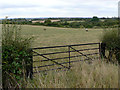
7
Field Bordering Dorket Head Quarry
Image: © Jonathan Clitheroe
Taken: 9 Sep 2024
0.20 miles
8
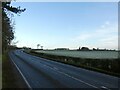
Blue skies and frosted fields
The B684 at the end of Mapperley Plains.
Image: © Alan Murray-Rust
Taken: 18 Jan 2023
0.21 miles
9
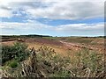
Dorket Head Clay Quarry
A fairly new addition to the landscape. Plans for the opening of the quarry were revealed as recently as 2018.
Image: © Jonathan Clitheroe
Taken: 9 Sep 2024
0.21 miles
10
View from near Arnold Lodge trig point
Extensive views over the Leen Valley and further the Trent Valley. In the middle distance is part of the Killisick housing estate of the 1970s and 80s.
Image: © Alan Murray-Rust
Taken: 21 Aug 2011
0.22 miles