IMAGES TAKEN NEAR TO
Peel Villas, NOTTINGHAM, NG3 5HZ
Introduction
This page details the photographs taken nearby to Peel Villas, NG3 5HZ by members of the Geograph project.
The Geograph project started in 2005 with the aim of publishing, organising and preserving representative images for every square kilometre of Great Britain, Ireland and the Isle of Man.

There are currently over 7.5m images from over14,400 individuals and you can help contribute to the project by visiting https://www.geograph.org.uk
Image Map
Images are licensed for reuse under creativecommons.org/licenses/by-sa/2.0
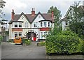
Notes
- Clicking on the map will re-center to the selected point.
- The higher the marker number, the further away the image location is from the centre of the postcode.
Image Listing (66 Images Found)
Images are licensed for reuse under creativecommons.org/licenses/by-sa/2.0
Image
Details
Distance
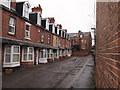
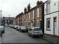
1
Nottingham - NG3
Two rows of terraced houses facing each other, with each house having its own tiny garden. This is Wycliffe Grove in the direction of Woodborough Road (B684) and it was taken from Quernby Road.
Image: © David Hallam-Jones
Taken: 21 Apr 2012
0.03 miles
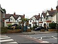
2
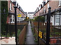
Agnes Villas
When built, these houses would have been sought after, with the luxury of a bay window giving extra space, and a convenient tram service into town just through the alleyway. Today, without any parking space adjacent they will be far less attractive (although the bus service is still frequent).
Image: © Alan Murray-Rust
Taken: 8 Mar 2009
0.03 miles
3
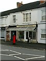
Espresso Gallery, Woodborough Road, Mapperley
The main reason for this photo is to show the pillar box which has the remains of a Post Office sign (like this https://www.geograph.org.uk/photo/4448444 ) on top, indicating that the premises were formerly a Post Office.
Image: © Alan Murray-Rust
Taken: 27 Nov 2022
0.03 miles
4
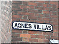
Agnes Villas
Typical Nottingham-style cast iron street name from the end of the 19th century
Image: © Alan Murray-Rust
Taken: 8 Mar 2009
0.03 miles
5
Nottingham - NG5
This row of houses, known as Agnes Villas, looking towards Woodborough Road (B684) was taken from Quernby Road. Perhaps each house had its own tiny front garden in the past, as the properties in the parallel "street" - Wycliffe Grove - do ?
Image: © David Hallam-Jones
Taken: 21 Apr 2012
0.04 miles
6
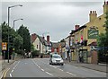
Mapperley: Woodborough Road
The current holder of the title does not appear on the sign of The Duke of Cambridge. To the right of the Belisha beacon on the left are the gates and the gable end of one of the houses in Image] .
Image: © John Sutton
Taken: 15 Jun 2014
0.05 miles
7
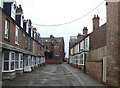
Mapperley: Agnes Villas
A view across Woodborough Road. For comparison, see Alan Murray-Rust's Image
Image: © John Sutton
Taken: 17 Jun 2014
0.06 miles
8
Mapperley Crescent, Woodborough Road
A discrete group of early 20th century housing in Arts and Crafts style, noticeably different from other development in the immediate locality.
Image: © Alan Murray-Rust
Taken: 27 Nov 2022
0.06 miles
9
Mapperley Crescent
A tight crescent of three pairs of Edwardian semi-detached houses and two detached ones, separated from Woodborough Road by gates.
Image: © John Sutton
Taken: 17 Jun 2014
0.06 miles
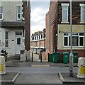
10
Staples Street, Mapperley
Although the road layout was developed at the same time as neighbouring Blyth Street Image, clearly there was more urgency in getting houses built.
Image: © Alan Murray-Rust
Taken: 8 Mar 2009
0.07 miles