IMAGES TAKEN NEAR TO
Zulla Road, NOTTINGHAM, NG3 5BY
Introduction
This page details the photographs taken nearby to Zulla Road, NG3 5BY by members of the Geograph project.
The Geograph project started in 2005 with the aim of publishing, organising and preserving representative images for every square kilometre of Great Britain, Ireland and the Isle of Man.

There are currently over 7.5m images from over14,400 individuals and you can help contribute to the project by visiting https://www.geograph.org.uk
Image Map
Images are licensed for reuse under creativecommons.org/licenses/by-sa/2.0
Notes
- Clicking on the map will re-center to the selected point.
- The higher the marker number, the further away the image location is from the centre of the postcode.
Image Listing (151 Images Found)
Images are licensed for reuse under creativecommons.org/licenses/by-sa/2.0
Image
Details
Distance
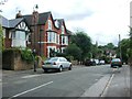
2
Mapperley Park Drive
Grand terraces line a road linking Magdala Road and Redcliffe Road (ahead).
Image: © John Sutton
Taken: 17 Jun 2014
0.02 miles
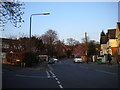
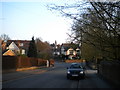
3
Up Zulla Road
Looking north from near the junction with Redcliffe Road on a clear May evening.
Image: © John Sutton
Taken: 20 May 2023
0.03 miles
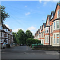
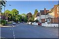
5
Junction of Redcliffe Road and Zulla Road
Redcliffe Road (centre) is one of the more significant roads through Mapperley Park, while Zulla Road (left foreground) parallels Mansfield Road for about a quarter of a mile, passing the backs of a few hotels.
Image: © Richard Vince
Taken: 12 Apr 2010
0.05 miles
6
Up Redcliffe Road
Redcliffe Road leads uphill through the southern end of Mapperley Park from Mansfield Road to Woodborough Road (ahead). Zulla Road is to the left and Thorncliffe Road to the right in this picture taken on a cloudless May evening.
Image: © John Sutton
Taken: 20 May 2023
0.05 miles
8
View north along Zulla Road
Taken from just north of the junction with Magdala Road. The junction with Shirley Road is just beyond the very pink, very blossom laden tree on the right.
Image: © Richard Vince
Taken: 12 Apr 2010
0.07 miles
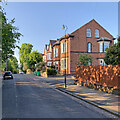
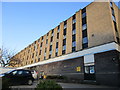
9
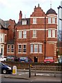
Corner turret
This former house with corner turret and Dutch gable is now part of the Westminster Hotel.
Image: © Michael Dibb
Taken: 30 Mar 2017
0.07 miles
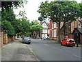
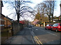
10
View south along Zulla Road
Redcliffe Road crosses the end of Zulla Road (see Image), with Thorncliffe Road just visible on the other side. The tower of St Andrew's church, on the corner of Mansfield Road and Mapperley Road, is visible on the horizon. The gateway to the right of the car leads to the car park of a large Park Inn hotel that fronts onto Mansfield Road.
Image: © Richard Vince
Taken: 12 Apr 2010
0.07 miles