IMAGES TAKEN NEAR TO
Mapperley Road, NOTTINGHAM, NG3 5BF
Introduction
This page details the photographs taken nearby to Mapperley Road, NG3 5BF by members of the Geograph project.
The Geograph project started in 2005 with the aim of publishing, organising and preserving representative images for every square kilometre of Great Britain, Ireland and the Isle of Man.

There are currently over 7.5m images from over14,400 individuals and you can help contribute to the project by visiting https://www.geograph.org.uk
Image Map
Images are licensed for reuse under creativecommons.org/licenses/by-sa/2.0
Notes
- Clicking on the map will re-center to the selected point.
- The higher the marker number, the further away the image location is from the centre of the postcode.
Image Listing (82 Images Found)
Images are licensed for reuse under creativecommons.org/licenses/by-sa/2.0
Image
Details
Distance
2
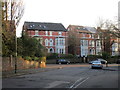
Houses on Mapperley Road
Some have been split into apartments and most have had loft conversions.
Image: © Jonathan Thacker
Taken: 15 Jan 2016
0.04 miles
4
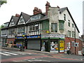
Nottingham, Woodborough Rd, NG3
A view of Alexandra Court from the opposite side of Woodborough Road, NG3. The older building in its shadow appears to have been converted into a number of small flats/studios although at present the access door at the side of it is gated and locked. The skylight on the roof of this smaller building suggests that if it was not originally built or used as a coach house for a nearby house it could, perhaps, have served as a utility building in the past e.g. a laundry or public baths? An unmade (and unadopted?) road extends along the side of this older property, leading to several very large Victorian houses in extensive grounds. One of the houses has planning permission for a number of smaller houses on it.
Image: © David Hallam-Jones
Taken: 11 Mar 2012
0.07 miles
5
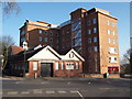
Nottingham - NG3 (Alexandra Court)
In ascending this section of Woodborough Road (B684) towards Mapperley this first building is the former coach house associated with the residence of John Player, the tobacco giant, that is situated further up on the road on the left where the cars are parked. The coach house is currently used by a light industrial enterprise. The former Player home now houses the Nottinghamshire Hospice. The road branching off to the left behind the lamp post is The Crescent and the property with the tall chimney was formerly a gatehouse.
Image: © David Hallam-Jones
Taken: 10 Jun 2012
0.07 miles
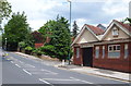
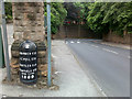
6
Junction of Woodborough Road and Magdala Road
There is an OS benchmark Image on a stone in the wall (pointed to by the lamp post shadow). The pillar box is Victorian.
Image: © Roger Templeman
Taken: 31 Mar 2013
0.07 miles
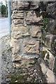
7
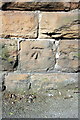
Benchmark at Woodborough Road / Magdala Road junction
Ordnanace Survey cut mark benchmark described on the Bench Mark Database at http://www.bench-marks.org.uk/bm47857
Image: © Roger Templeman
Taken: 31 Mar 2013
0.07 miles
8
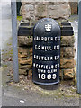
Boundary Marker, Redcliffe Road top
One of a pair of surviving Nottingham boundary markers on Redcliffe Road, dating from 1869. These were erected in relation to defining boundaries of Poor Law districts. Listed Grade II. Compared with the other http://www.geograph.org.uk/photo/3903440, only the office of Town Clerk has been picked out in white. See http://www.geograph.org.uk/photo/3903442 for location.
Image: © Alan Murray-Rust
Taken: 18 Mar 2014
0.08 miles
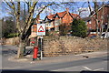
9
Town Boundary Post
At the junction of Mapperley Road and Redcliffe Road.
Image: © David Lally
Taken: 12 Jun 2009
0.08 miles
10
Benchmark on wall at Mapperley Road / Redcliffe Road junction
Ordnance Survey cut mark benchmark described on the Bench Mark Database at http://www.bench-marks.org.uk/bm47933
Image is a view of the junction from the other side of the wall pier.
Image: © Roger Templeman
Taken: 1 Apr 2013
0.08 miles