IMAGES TAKEN NEAR TO
Malcolm Close, NOTTINGHAM, NG3 5AP
Introduction
This page details the photographs taken nearby to Malcolm Close, NG3 5AP by members of the Geograph project.
The Geograph project started in 2005 with the aim of publishing, organising and preserving representative images for every square kilometre of Great Britain, Ireland and the Isle of Man.

There are currently over 7.5m images from over14,400 individuals and you can help contribute to the project by visiting https://www.geograph.org.uk
Image Map
Images are licensed for reuse under creativecommons.org/licenses/by-sa/2.0
Notes
- Clicking on the map will re-center to the selected point.
- The higher the marker number, the further away the image location is from the centre of the postcode.
Image Listing (280 Images Found)
Images are licensed for reuse under creativecommons.org/licenses/by-sa/2.0
Image
Details
Distance
1
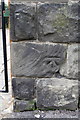
Benchmark on wall fronting #27 Mapperley Road
Ordnance Survey cut mark benchmark described on the Bench Mark Database at http://www.bench-marks.org.uk/bm47856
Image: © Roger Templeman
Taken: 1 Apr 2013
0.03 miles
2
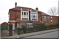
#27 Mapperley Road
There is an OS benchmark Image on a wall stone to the right of the pedestrian gate
Image: © Roger Templeman
Taken: 1 Apr 2013
0.03 miles
3
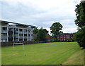
Nottingham - NG3 (Bellevue)
A school playing field belonging to St Augustine's R/C Primary School is overlooked by a low-rise block of luxury apartments. Mapperley Road at the far end of the football pitch.
Image: © David Hallam-Jones
Taken: 17 Jun 2012
0.04 miles
4

Down Elm Avenue
A zoom view towards Cranmer Street and Mansfield Road, with Ratcliffe-on-Soar power station on the hazy skyline, eight miles or so away. "The wise policy of the Corporation in providing these stately avenues of elms and oaks in the midst of the crowded city is self-evident; the only regret is that things are not more so, as we see meadows and gardens rapidly despoiled by the builder in utter neglect of the things which go to make life—especially child-life—healthy and bright" (Illustrated Handbook to Nottingham, 1906).
Image: © John Sutton
Taken: 23 Jun 2014
0.04 miles
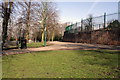
5

Elm Avenue, looking down from Belle Vue reservoir
The trees planted to replace the elms which were destroyed by Dutch Elm Disease in the 1970s are now reaching maturity.
Image: © Alan Murray-Rust
Taken: 27 Nov 2022
0.04 miles
6
![Elm Avenue [3]](https://s1.geograph.org.uk/geophotos/05/34/97/5349777_f2cd5c4d_120x120.jpg)
Elm Avenue [3]
Elm Avenue from Cranmer Street, looking towards Bellvue Reservoir.
This delightful traffic-free avenue runs, as Elm Avenue, from Huntingdon Road, A60, to Bellvue Reservoir then as Corporation Oaks and as Robin Hood Chase to St Ann's Well Road.
Image: © Michael Dibb
Taken: 31 Mar 2017
0.05 miles
7
Junction of Elm Avenue and path around Bellevue Reservoir
There is an OS benchmark Image on the wall of the covered reservoir opposite the top of Elm Avenue
Image: © Roger Templeman
Taken: 31 Mar 2013
0.05 miles
8

Corporation Oaks at Belle Vue Reservoir
There is a benchmark https://www.geograph.org.uk/photo/7353544 below the graffiti to the right.
Image: © Alan Murray-Rust
Taken: 27 Nov 2022
0.05 miles
9
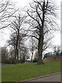
Corporation Oaks
The circuit around the Belle Vue reservoir (to the right) is called Corporation Oaks, but these trees look more like lime trees to me. This is part of the green corridor created in the 1870s stretching from the Arboretum to St Anns Well Road.
Image: © Alan Murray-Rust
Taken: 8 Mar 2009
0.05 miles
10
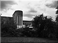
The Elms Primary School
Closed in 2008. http://digitalanthill.com/elms-primary-schoolabandoned/
Image: © David Lally
Taken: 5 Aug 2017
0.05 miles