IMAGES TAKEN NEAR TO
Mapperley Road, NOTTINGHAM, NG3 5AA
Introduction
This page details the photographs taken nearby to Mapperley Road, NG3 5AA by members of the Geograph project.
The Geograph project started in 2005 with the aim of publishing, organising and preserving representative images for every square kilometre of Great Britain, Ireland and the Isle of Man.

There are currently over 7.5m images from over14,400 individuals and you can help contribute to the project by visiting https://www.geograph.org.uk
Image Map
Images are licensed for reuse under creativecommons.org/licenses/by-sa/2.0
Notes
- Clicking on the map will re-center to the selected point.
- The higher the marker number, the further away the image location is from the centre of the postcode.
Image Listing (319 Images Found)
Images are licensed for reuse under creativecommons.org/licenses/by-sa/2.0
Image
Details
Distance
1
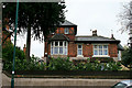
Watson Fothergill alterations
To a house on Mapperley Road. The alterations were done in 1890.
Image: © David Lally
Taken: 6 May 2010
0.02 miles
2
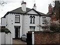
Fine houses
A fine and interesting pair of semi-detached houses in Mapperley Road.
Image: © Michael Dibb
Taken: 31 Mar 2017
0.04 miles
3
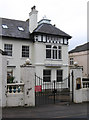
Nottingham - white rendered house on Villa Road
Image: © Dave Bevis
Taken: 25 Feb 2013
0.04 miles
4
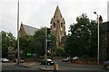
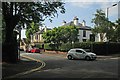
St. Andrew's Church
Located at the junction of Mansfield Road with Forest Road East and Mapperley Road. Near this spot, before the Church was built, was the gallows.
Image: © Mick Garratt
Taken: 29 Aug 2007
0.05 miles
5
Chestnut Grove
Victorian cul-de-sac off Mapperley Road. The rustic stone walling is a typical feature of the Nottingham area from this period.
Image: © Alan Murray-Rust
Taken: 8 Mar 2009
0.05 miles
6
![Parish church [3]](https://s2.geograph.org.uk/geophotos/05/35/07/5350714_477be339_120x120.jpg)
Parish church [3]
The community hall of St Andrew's church. Built in 1871 with 1884 additions, the church of St Andrew is sited in a dominant position on a ridge. In the Gothic Revival style, the church is listed, grade II*, with details at: https://www.historicengland.org.uk/listing/the-list/list-entry/1058983
Image: © Michael Dibb
Taken: 31 Mar 2017
0.05 miles
7
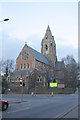
St Andrew's Church from Forest Road East
The church's spire is an Ordnance Survey intersected station trig point, http://www.trigpointinguk.com/trigs/trig-details.php?t=10524
Image: © Roger Templeman
Taken: 30 Mar 2013
0.05 miles
8
![Parish church [2]](https://s2.geograph.org.uk/geophotos/05/34/90/5349074_b0f1f44b_120x120.jpg)
Parish church [2]
Built in 1871 with 1884 additions, the church of St Andrew is sited in a dominant position on a ridge. In the Gothic Revival style, the church is listed, grade II*, with details at: https://www.historicengland.org.uk/listing/the-list/list-entry/1058983
Image: © Michael Dibb
Taken: 31 Mar 2017
0.05 miles
9
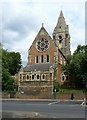
Church of St Andrew, Mansfield Road, Nottingham
Classic 19th century urban expansion church in Gothic style, architect William Knight, built 1869-71. The lean-to baptistery was added in 1884 by S R Stevenson. Listed Grade II*.
Image: © Alan Murray-Rust
Taken: 12 Aug 2019
0.05 miles
10
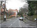
The corner of Mapperley Road and Cranmer Street
A hot first morning in July.
Image: © John Sutton
Taken: 1 Jul 2015
0.05 miles