IMAGES TAKEN NEAR TO
Hungerhill Road, NOTTINGHAM, NG3 4QB
Introduction
This page details the photographs taken nearby to Hungerhill Road, NG3 4QB by members of the Geograph project.
The Geograph project started in 2005 with the aim of publishing, organising and preserving representative images for every square kilometre of Great Britain, Ireland and the Isle of Man.

There are currently over 7.5m images from over14,400 individuals and you can help contribute to the project by visiting https://www.geograph.org.uk
Image Map
Images are licensed for reuse under creativecommons.org/licenses/by-sa/2.0
Notes
- Clicking on the map will re-center to the selected point.
- The higher the marker number, the further away the image location is from the centre of the postcode.
Image Listing (56 Images Found)
Images are licensed for reuse under creativecommons.org/licenses/by-sa/2.0
Image
Details
Distance
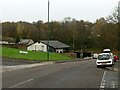
1
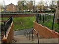
Steps down to the subway, Hungerhill Road
The subway was filled in around 2010 as a social safety measure. See also https://www.geograph.org.uk/photo/7351897 .
Image: © Alan Murray-Rust
Taken: 27 Nov 2022
0.03 miles
2
Tulip Avenue
This is the vehicle access to the houses seen in Image
Image: © Alan Murray-Rust
Taken: 8 Mar 2009
0.04 miles
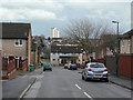
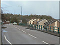
3
Hungerhill Road at Norland Close
Typical of the 1970s redevelopment of the St Ann's area with separation of pedestrian and vehicular traffic. The Zebra crossing in the foreground replaced the subway beyond, stopped up in around 2010 for social safety reasons. See also https://www.geograph.org.uk/photo/7351899 .
Image: © Alan Murray-Rust
Taken: 27 Nov 2022
0.04 miles
4
Sycamore
1970s pub built as part of the St Anns redevelopment.
Image: © Alan Murray-Rust
Taken: 8 Mar 2009
0.07 miles
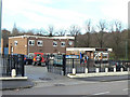
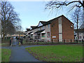
5
The east end of Abbotsford Drive, St Ann's
The building is the Kingdom Hall of Jehovah's Witnesses, opened in 2018 on the site of the former Sycamore public house https://www.geograph.org.uk/photo/1197233 which was demolished in 2014.
Image: © Alan Murray-Rust
Taken: 27 Nov 2022
0.08 miles
6
Tulip Avenue
Part of the St Anns redevelopment of the early 1970s.
Image: © Alan Murray-Rust
Taken: 8 Mar 2009
0.08 miles
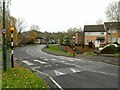
7
Abbotsford Drive
Looking east from the bridge over Robin Hood Chase. The road was built on a completely new alignment as part of the redevelopment of St Anns during the 1970s.
Image: © Alan Murray-Rust
Taken: 8 Mar 2009
0.08 miles
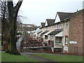
8
149-183 Tulip Avenue, Nottingham
Unusually, the entrance to each of these houses is by means of a bridge to a porch on the middle storey.
Image: © Stephen Craven
Taken: 18 Jan 2020
0.09 miles
9
Subway on Robin Hood Chase
With a quite charming paint make-over.
Image: © David Lally
Taken: 6 Oct 2017
0.10 miles
10
"Little boxes on the hillside . . .
. . . and they're all made out of ticky-tacky
And they all look just the same."
Many people will remember these words sung by Pete Seeger, but the inhabitants of these houses mainly didn't get to University, or become doctors or lawyers.
Although an improvement on the cramped terraces from the early part of the 19th century, the redevelopment of St Anns from the late 1960s hasn't prevented the area from being one with a poor reputation, although it has improved recently.
Image: © Alan Murray-Rust
Taken: 8 Mar 2009
0.10 miles