IMAGES TAKEN NEAR TO
Hungerhill Road, NOTTINGHAM, NG3 4QA
Introduction
This page details the photographs taken nearby to Hungerhill Road, NG3 4QA by members of the Geograph project.
The Geograph project started in 2005 with the aim of publishing, organising and preserving representative images for every square kilometre of Great Britain, Ireland and the Isle of Man.

There are currently over 7.5m images from over14,400 individuals and you can help contribute to the project by visiting https://www.geograph.org.uk
Image Map
Images are licensed for reuse under creativecommons.org/licenses/by-sa/2.0
Notes
- Clicking on the map will re-center to the selected point.
- The higher the marker number, the further away the image location is from the centre of the postcode.
Image Listing (100 Images Found)
Images are licensed for reuse under creativecommons.org/licenses/by-sa/2.0
Image
Details
Distance
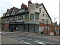
1
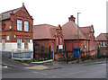
Nottingham - former school on Hungerhill Road
Image: © Dave Bevis
Taken: 25 Feb 2013
0.04 miles
2
Brendon Lawrence Sports Centre
Seen from across Alexandra Park. Brendon Lawrence was an innocent sixteen year old who was shot and murdered in St. Ann's in 2002.
A moving poem to the memory of Brendon Lawrence can be found here: http://www.benjaminzephaniah.com/outernet.html#michelle
Image: © Mick Garratt
Taken: 5 Jan 2007
0.04 miles
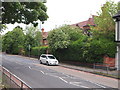
3
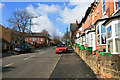
Hungerhill Road
Rising steeply up to the junction with Woodborough Road.
Image: © David Lally
Taken: 2 Mar 2010
0.07 miles
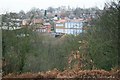
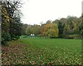
4
Alexandra Park
off Hungerhill Road, Nottingham
Image: © Tom Courtney
Taken: 26 Aug 2005
0.08 miles
5
Dilapidated Shops on Woodborough Road
Where St Ann's and Mapperley meet.
Image: © David Lally
Taken: 12 Jun 2009
0.09 miles
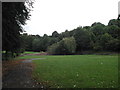
6
Sycamore Park, St Ann's
Recreating this 'First' for the square https://www.geograph.org.uk/photo/43315 . The children's play area visible in the distance in that view has been moved close to Hungerhill Road behind the photographer and replaced with a ball-play area. I can find no information to suggest that the park has ever been called Alexandra Park. Although this appears on OS maps, it applies to a largely aborted Victorian major residential development adjacent to the northern end of the park.
Image: © Alan Murray-Rust
Taken: 27 Nov 2022
0.09 miles
7
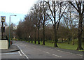
Hungerhill Road and recreation ground
This end of the road was originally Sycamore Road, from which the pub on the corner takes its name.
Image: © Alan Murray-Rust
Taken: 8 Mar 2009
0.09 miles
8
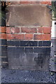
Benchmark on wall pier of #308 Woodborough Road
Ordnance Survey cut mark benchmark described on the Bench Mark Database at http://www.bench-marks.org.uk/bm47881
Image: © Roger Templeman
Taken: 31 Mar 2013
0.09 miles
9
Nottingham - NG3 (Alexandra Park Area)
A few metres further up this section of Woodborough Road, just after the right-hand Hungerhill Road turning, are the Lambley Almshouses. Turner, D., believes these replacement almshouses to have designed by Arthur Brown (1851-1935), Nottingham Corporation’s Engineer. (See http://www.theworksofwatsonfothergill.weebly.com ) This particular row, built in 1897 and consisting of twelve single-bedroomed dwellings, was built as a replacement for The Lambley Hospitals (i.e. almshouses) that existed at the summit of Derby Road. It seems that a charitable body - funded by the wealth of an estate owner in Lambley, Notts - financed the construction of the original complex of 22 rooms and various communal facilities in Derby Road for deserving burgesses, or their widows. They were however, replaced c.1896.
Image: © David Hallam-Jones
Taken: 10 Jun 2012
0.09 miles
10
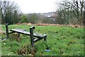
Seat, Alexandra Park
Looking across the park towards the city.
Image: © Mick Garratt
Taken: 5 Jan 2007
0.10 miles