IMAGES TAKEN NEAR TO
Verbena Close, NOTTINGHAM, NG3 4PZ
Introduction
This page details the photographs taken nearby to Verbena Close, NG3 4PZ by members of the Geograph project.
The Geograph project started in 2005 with the aim of publishing, organising and preserving representative images for every square kilometre of Great Britain, Ireland and the Isle of Man.

There are currently over 7.5m images from over14,400 individuals and you can help contribute to the project by visiting https://www.geograph.org.uk
Image Map
Images are licensed for reuse under creativecommons.org/licenses/by-sa/2.0
Notes
- Clicking on the map will re-center to the selected point.
- The higher the marker number, the further away the image location is from the centre of the postcode.
Image Listing (126 Images Found)
Images are licensed for reuse under creativecommons.org/licenses/by-sa/2.0
Image
Details
Distance
1
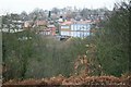
Brendon Lawrence Sports Centre
Seen from across Alexandra Park. Brendon Lawrence was an innocent sixteen year old who was shot and murdered in St. Ann's in 2002.
A moving poem to the memory of Brendon Lawrence can be found here: http://www.benjaminzephaniah.com/outernet.html#michelle
Image: © Mick Garratt
Taken: 5 Jan 2007
0.05 miles
2

Down Woodborough Road
Looking towards the city from near the Hungerhill Road bus stop. A City Transport bus bound for Gedling or Arnold is coming up the hill.
Image: © John Sutton
Taken: 23 Jun 2014
0.06 miles
3
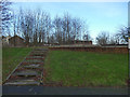
Steps to a derelict site
Whatever buildings once stood here to the north of Robin Hood Chase have been demolished.
Image: © Stephen Craven
Taken: 18 Jan 2020
0.06 miles
4
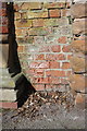
Benchmark on Woodborough Road wall
This Ordnance Survey cut mark benchmark is on a short section of wall to the right of a wall pier at the southeast end of Corporation Oaks and is described on the Bench Mark Database at http://www.bench-marks.org.uk/bm47880
Image: © Roger Templeman
Taken: 31 Mar 2013
0.07 miles
5
Junction of Woodborough Road and Corporation Oaks
There is an OS benchmark Image on the wall to the right of the wall pier to the right of the telephone kiosk
Image: © Roger Templeman
Taken: 31 Mar 2013
0.07 miles
6
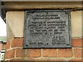
Notice on gate pier, Corporation Oaks, Woodborough Road
See https://www.geograph.org.uk/photo/7351940 for location. In practice, these walks, although for many years locked once a year to maintain their non-highway status, are now designated as pedestrian rights of way.
Image: © Alan Murray-Rust
Taken: 27 Nov 2022
0.07 miles
7
Corporation Oaks at Woodborough Road
Part of the series of pedestrian avenues created in 1851 as a result of the then recent Inclosures to the north of the City centre. Not originally dedicated to the public under the Highways Acts, they are now formally designated as pedestrian rights of way.
Image: © Alan Murray-Rust
Taken: 27 Nov 2022
0.07 miles
8
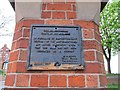
Notice of rights of way, entrance to Corporation Oaks
The status of the walks along Robin Hood Chase, Corporation Oaks and Elm Avenue has recently changed: Nottingham City Council has designated this as public rights of way and cyclepaths.
Image: © SK53
Taken: 26 Apr 2011
0.07 miles
9
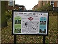
The Inclosure Walk, no.5
One of a series of boards at key locations around the walk described on the board, taking in the main locations associated with the mid 19th century Inclosures of the borough.
Image: © Alan Murray-Rust
Taken: 27 Nov 2022
0.07 miles
10
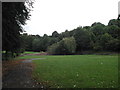
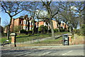
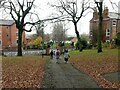
Alexandra Park
off Hungerhill Road, Nottingham
Image: © Tom Courtney
Taken: 26 Aug 2005
0.08 miles