IMAGES TAKEN NEAR TO
Plowright Court, NOTTINGHAM, NG3 4LJ
Introduction
This page details the photographs taken nearby to Plowright Court, NG3 4LJ by members of the Geograph project.
The Geograph project started in 2005 with the aim of publishing, organising and preserving representative images for every square kilometre of Great Britain, Ireland and the Isle of Man.

There are currently over 7.5m images from over14,400 individuals and you can help contribute to the project by visiting https://www.geograph.org.uk
Image Map
Images are licensed for reuse under creativecommons.org/licenses/by-sa/2.0
Notes
- Clicking on the map will re-center to the selected point.
- The higher the marker number, the further away the image location is from the centre of the postcode.
Image Listing (140 Images Found)
Images are licensed for reuse under creativecommons.org/licenses/by-sa/2.0
Image
Details
Distance
1

Down Woodborough Road
Looking towards the city from near the Hungerhill Road bus stop. A City Transport bus bound for Gedling or Arnold is coming up the hill.
Image: © John Sutton
Taken: 23 Jun 2014
0.01 miles
2

Woodborough Road: Bowers Avenue
Typical three-storey Victorian houses on one of the many steep streets on the hilly eastern side of the city.
Image: © John Sutton
Taken: 23 Jun 2014
0.03 miles
3
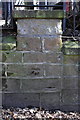
Benchmark on wall pier on Corporation Oaks
Ordnance Survey cut mark benchmark described on the Bench Mark Database at http://www.bench-marks.org.uk/bm47879
Image: © Roger Templeman
Taken: 31 Mar 2013
0.05 miles
4
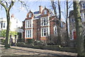
Houses on the NE side of Corporation Oaks
The middle two houses are #22 and #20 (the right one of the pair). There is an OS benchmark Image on the pier at the end of the party wall between #18 and #20 (below the middle window of #20 in the image)
Image: © Roger Templeman
Taken: 31 Mar 2013
0.05 miles
5

Corporation Oaks
Looking towards Woodborough Road on a bright June morning.
Image: © John Sutton
Taken: 23 Jun 2014
0.05 miles
6
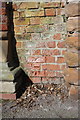
Benchmark on Woodborough Road wall
This Ordnance Survey cut mark benchmark is on a short section of wall to the right of a wall pier at the southeast end of Corporation Oaks and is described on the Bench Mark Database at http://www.bench-marks.org.uk/bm47880
Image: © Roger Templeman
Taken: 31 Mar 2013
0.06 miles
7
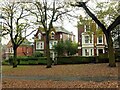
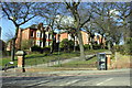
Victorian villas alongside Corporation Oaks
At the time these would have been prestigious sites. At first sight the lack of vehicle access to the frontage might appear problematical, especially in the age of the motor car, but in practice the houses are all served at the rear, some with original Victorian coach houses.
Image: © Alan Murray-Rust
Taken: 27 Nov 2022
0.06 miles
8
Outlet meters for Belle Vue Reservoir
I'm guessing at the function of what lies beneath this large access cover. The presence of an adjacent cabinet and phone line suggests telemetry (remote measurement) of the flow in the mains leading out of the reservoir at the top of the hill Image See Image for context.
Image: © Stephen Craven
Taken: 18 Jan 2020
0.06 miles
9
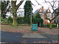
Junction of Woodborough Road and Corporation Oaks
There is an OS benchmark Image on the wall to the right of the wall pier to the right of the telephone kiosk
Image: © Roger Templeman
Taken: 31 Mar 2013
0.06 miles
10
Notice on gate pier, Corporation Oaks, Woodborough Road
See https://www.geograph.org.uk/photo/7351940 for location. In practice, these walks, although for many years locked once a year to maintain their non-highway status, are now designated as pedestrian rights of way.
Image: © Alan Murray-Rust
Taken: 27 Nov 2022
0.06 miles