IMAGES TAKEN NEAR TO
St. Anns Hill, NOTTINGHAM, NG3 4LB
Introduction
This page details the photographs taken nearby to St. Anns Hill, NG3 4LB by members of the Geograph project.
The Geograph project started in 2005 with the aim of publishing, organising and preserving representative images for every square kilometre of Great Britain, Ireland and the Isle of Man.

There are currently over 7.5m images from over14,400 individuals and you can help contribute to the project by visiting https://www.geograph.org.uk
Image Map
Images are licensed for reuse under creativecommons.org/licenses/by-sa/2.0
Notes
- Clicking on the map will re-center to the selected point.
- The higher the marker number, the further away the image location is from the centre of the postcode.
Image Listing (176 Images Found)
Images are licensed for reuse under creativecommons.org/licenses/by-sa/2.0
Image
Details
Distance
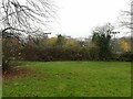
1

Corporation Oaks top
The pathway encircles the Belle Vue reservoir, built in the 1850s, which provided Nottingham with a clean supply of water that limited its exposure to the cholera outbreaks of the mid 19th century.
Image: © Alan Murray-Rust
Taken: 27 Nov 2022
0.02 miles
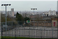
2
View to the City Centre from Belle Vue reservoir
An interesting comparison with this 2009 view https://www.geograph.org.uk/photo/1196704 , with less of the city visible due to tree growth. The Newton Building of Nottingham Trent University is the only matching landmark. The vista of the city promised when Corporation Oaks was developed is no longer available!
Image: © Alan Murray-Rust
Taken: 27 Nov 2022
0.03 miles
3
View to the City Centre from Belle Vue reservoir
In the foreground the playground of The Elms School.
Distant buildings include (from left to right) Victoria Centre flats, Council House and the Newton Building of Nottingham Trent University.
Image: © Alan Murray-Rust
Taken: 8 Mar 2009
0.04 miles
4
Corporation Oaks from Belle Vue
Corporation Oaks is part of the green corridor stretching round the north and east of the City Centre from the Arboretum to St Anns Well Road, built around the 1870s.
Image: © Alan Murray-Rust
Taken: 8 Mar 2009
0.04 miles
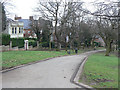
5
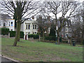
Nottingham - NG3 (Bellevue)
Looking down Corporation Oaks towards Woodborough Road (B684). This picture was taken from the footpath encircling the covered Bellevue reservoir.
Image: © David Hallam-Jones
Taken: 10 Jun 2012
0.04 miles
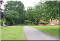
6
Corporation Oaks, Nottingham - upper section
The 1845 Enclosure Act set aside 130 acres of land to the north and east of Nottingham city centre as public open space, comprising Queen's Walk, Queen's Walk Park, Victoria Park, Robin Hood Chase, Corporation Oaks, St Ann's Hill, Elm Avenue, the Arboretum, the General Cemetery, Waterloo Promenade, Church Cemetery, and The Forest. This is a view looking down Corporation Oaks from by Belle Vue reservoir.
Image: © Stephen Craven
Taken: 18 Jan 2020
0.04 miles
7
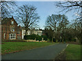
Victorian Villas on Corporation Oaks
A villa facing this attractive avenue would have been a prime target for Nottingham's wealthier business people - there's a road at the back for your carriage, of course.
Corporation Oaks is part of the green corridor stretching round the north and east of the City Centre from the Arboretum to St Anns Well Road, built around the 1870s.
Image: © Alan Murray-Rust
Taken: 8 Mar 2009
0.04 miles
8
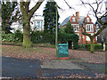
Outlet meters for Belle Vue Reservoir
I'm guessing at the function of what lies beneath this large access cover. The presence of an adjacent cabinet and phone line suggests telemetry (remote measurement) of the flow in the mains leading out of the reservoir at the top of the hill Image See Image for context.
Image: © Stephen Craven
Taken: 18 Jan 2020
0.05 miles
9
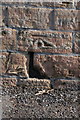
Benchmark on wall of Bellevue Reservoir
Ordnance Survey cut mark benchmark described on the Bench Mark Database at http://www.bench-marks.org.uk/bm38429
Image: © Roger Templeman
Taken: 31 Mar 2013
0.05 miles
10

Bench mark, Belle Vue Reservoir
Looking even more worn than in 2013 https://www.geograph.org.uk/photo/3401334 . See https://www.geograph.org.uk/photo/7353548 for location.
Image: © Alan Murray-Rust
Taken: 27 Nov 2022
0.05 miles