IMAGES TAKEN NEAR TO
Cranmer Street, NOTTINGHAM, NG3 4GH
Introduction
This page details the photographs taken nearby to Cranmer Street, NG3 4GH by members of the Geograph project.
The Geograph project started in 2005 with the aim of publishing, organising and preserving representative images for every square kilometre of Great Britain, Ireland and the Isle of Man.

There are currently over 7.5m images from over14,400 individuals and you can help contribute to the project by visiting https://www.geograph.org.uk
Image Map (Loading...)


Getting Data...Please wait
Leaflet Map data © OpenStreetMap
Images are licensed for reuse under creativecommons.org/licenses/by-sa/2.0
Notes
- Clicking on the map will re-center to the selected point.
- The higher the marker number, the further away the image location is from the centre of the postcode.
Image Listing (313 Images Found)
Images are licensed for reuse under creativecommons.org/licenses/by-sa/2.0
Image
Details
Distance
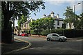
1
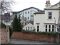
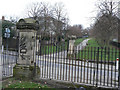
A contrast in styles
But whether you want modern or Victorian, it's all the upper end of the market. Off Cranmer Street.
Image: © Alan Murray-Rust
Taken: 8 Mar 2009
0.01 miles
2
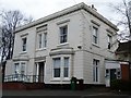
Villa Road
This does indeed have a number of large Victorian villas; the right hand side has the coach houses of the houses which front onto Elm Avenue.
Image: © Alan Murray-Rust
Taken: 8 Mar 2009
0.02 miles
3
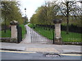
Elm Avenue, Nottingham - upper section
The 1845 Enclosure Act set aside 130 acres of land to the north and east of Nottingham city centre as public open space, comprising Queen's Walk, Queen's Walk Park, Victoria Park, Robin Hood Chase, Corporation Oaks, St Ann's Hill, Elm Avenue, the Arboretum, the General Cemetery, Waterloo Promenade, Church Cemetery, and The Forest.
Image: © Stephen Craven
Taken: 18 Jan 2020
0.02 miles
4
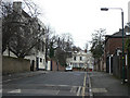
Fine property
This fine house on the corner of Cramner Street and Mapperley Road is now used as offices for the National Society for the Prevention of Cruelty to Children.
Image: © Michael Dibb
Taken: 31 Mar 2017
0.03 miles
5
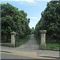
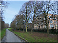
Up Elm Avenue from Cranmer Street
In 1833 a Select Committee on Public Walks recommended the creation of “properly regulated” public walks for the “middle and humbler classes” in order to improve “their cleanliness, neatness and personal appearance” and provide a venue for a man to show off his wife and well-behaved children. Such walks were seen as an alternative to the “drinking shops, where, in short-lived excitement, they may forget their toil, but where they waste the means of their families and too often destroy their health”.
It became possible to implement these recommendations after the 1845 Enclosure Act, and by 1852 walks and other green spaces had been established in an arc north of the town centre, from Robin Hood Chase in the east, along Corporation Oaks and Elm Avenue to the Arboretum and the General Cemetery. The Forest recreation ground was also established.
A journalist then wrote that “Nottingham might vie with any town in England for its well-grown and well-dressed women of the operative classes who on Sunday throng the park and public walks.”
(All of this information comes from “The transformation of green space in old and new Nottingham” in Volume 118 of the Transactions of the Thoroton Society.)
Image: © John Sutton
Taken: 6 Jul 2015
0.03 miles
6
Nottingham - NG1
The Elm Avenue/Bellevue (covered reservoir) section of a longer footpath that runs from Huntingdon Street - where the A60 enters the city centre - and Woodborough Road. From a hot air balloon the observer would probably see a rosette-shaped structure below her/him with the footpaths projecting from the circular part the rosette (i.e. the covered reservoir) with the grass-edged footpaths forming the rosette's ribbons.
Image: © David Hallam-Jones
Taken: 20 Apr 2012
0.03 miles
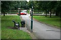
8
Elm Avenue at Cranmer Street
At this scale the gateposts look to be the same, but a closer look reveals that each is dedicated to a different tree or plant.
Elm Avenue and the Chase capitals http://www.geograph.org.uk/search.php?i=5558919&displayclass=slide
Image: © Alan Murray-Rust
Taken: 8 Mar 2009
0.04 miles
9
The corner of Mapperley Road and Cranmer Street
A hot first morning in July.
Image: © John Sutton
Taken: 1 Jul 2015
0.04 miles
10
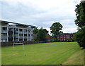
Nottingham - NG3 (Bellevue)
A school playing field belonging to St Augustine's R/C Primary School is overlooked by a low-rise block of luxury apartments. Mapperley Road at the far end of the football pitch.
Image: © David Hallam-Jones
Taken: 17 Jun 2012
0.04 miles