IMAGES TAKEN NEAR TO
Elm Avenue, NOTTINGHAM, NG3 4GF
Introduction
This page details the photographs taken nearby to Elm Avenue, NG3 4GF by members of the Geograph project.
The Geograph project started in 2005 with the aim of publishing, organising and preserving representative images for every square kilometre of Great Britain, Ireland and the Isle of Man.

There are currently over 7.5m images from over14,400 individuals and you can help contribute to the project by visiting https://www.geograph.org.uk
Image Map
Images are licensed for reuse under creativecommons.org/licenses/by-sa/2.0
Notes
- Clicking on the map will re-center to the selected point.
- The higher the marker number, the further away the image location is from the centre of the postcode.
Image Listing (323 Images Found)
Images are licensed for reuse under creativecommons.org/licenses/by-sa/2.0
Image
Details
Distance
1
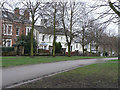
Villas on Elm Avenue
The houses on the east side of the avenue are generally less pretentious than those on the opposite side.
Image: © Alan Murray-Rust
Taken: 8 Mar 2009
0.01 miles
2
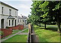
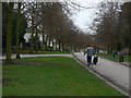
Houses on Elm Avenue
In 1833 a Select Committee on Public Walks recommended the creation of “properly regulated” public walks for the “middle and humbler classes” in order to improve “their cleanliness, neatness and personal appearance” and provide a venue for a man to show off his wife and well-behaved children. Such walks were seen as an alternative to the “drinking shops, where, in short-lived excitement, they may forget their toil, but where they waste the means of their families and too often destroy their health”.
It became possible to implement these recommendations after the 1845 Enclosure Act, and by 1852 walks and other green spaces had been established in an arc north of the town centre, from Robin Hood Chase in the east, along Corporation Oaks and Elm Avenue to the Arboretum and the General Cemetery. The Forest recreation ground was also established.
A journalist then wrote that “Nottingham might vie with any town in England for its well-grown and well-dressed women of the operative classes who on Sunday throng the park and public walks.”
(All of this information comes from “The transformation of green space in old and new Nottingham” in Volume 118 of the Transactions of the Thoroton Society.)
Image: © John Sutton
Taken: 6 Jul 2015
0.01 miles
3

Benchmark on former works building, St Anns Hill Road
Ordnance Survey cut mark benchmark described on the Bench Mark Database at http://www.bench-marks.org.uk/bm47927
Image: © Roger Templeman
Taken: 1 Apr 2013
0.02 miles
4
Junction of Egerton Street and St Anns Hill Road
Former works building now housing recording studios. There is an OS benchmark Image on the near corner, under the H sign and left of the white-painted bricks around the entrance to Dance School (Arabic & Brazilian Culture and Dance)
Image: © Roger Templeman
Taken: 1 Apr 2013
0.02 miles
5
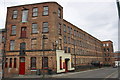
St Ann's Hill Road: Oldknow's Factory
A Grade II listed lace factory of the 1850s, now a "centre of creative enterprise". The enterprises include a dance studio and, appropriately, a lace and textile company. For the very informative listing text, see http://www.britishlistedbuildings.co.uk/en-492001-oldknows-factory-#.VZ_f5CiwHZY .
To the left, fronting Egerton Street, is the slightly older part of the building.
Image: © John Sutton
Taken: 6 Jul 2015
0.02 miles
6
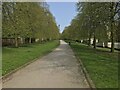
Elm Avenue
Part of a green corridor created probably in the 1870s, stretching from the Arboretum round the north east of the City to St Ann's. Other parts still retain the mature trees planted at the inception, but the age of trees along here suggests that the originals were elms which succumbed to the Dutch Elm Disease disaster of the late 70s.
Image: © Alan Murray-Rust
Taken: 8 Mar 2009
0.03 miles
7
![Elm Avenue [1]](https://s0.geograph.org.uk/geophotos/05/34/97/5349764_5b30e7c5_120x120.jpg)
Elm Avenue [1]
Elm Avenue from Huntingdon Road. This is the reverse view to Image
This delightful traffic-free avenue runs, As Elm Avenue, from Huntingdon Road, A60, to Bellvue Reservoir then as Corporation Oaks and as Robin Hood Chase to St Ann's Well Road.
Image: © Michael Dibb
Taken: 31 Mar 2017
0.03 miles
9
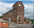
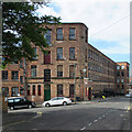
Oldknow's Factory, Egerton Street, Nottingham
A fine former lace factory built c1850. Grade II listed.
Now rentable office space.
Image: © Stephen Richards
Taken: 19 Jun 2015
0.03 miles
10
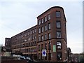
Oldknow's Factory [1]
This large lace making factory complex, known as Oldnow's Factory. The complex comprises two linked factory ranges and a separate ancillary building, currently partly vacant and partly in use as studios, offices, workshops and for textile manufacturing. This view is of the slightly more recent St Ann's Hill Road range, built circa 1855 for Hartshorn & Oldknow, lace manufacturers.
The complex is listed, grade II, and there is much history and detail at: https://www.historicengland.org.uk/listing/the-list/list-entry/1391487
Image: © Michael Dibb
Taken: 31 Mar 2017
0.03 miles