IMAGES TAKEN NEAR TO
Robin Hood Chase, NOTTINGHAM, NG3 4EZ
Introduction
This page details the photographs taken nearby to Robin Hood Chase, NG3 4EZ by members of the Geograph project.
The Geograph project started in 2005 with the aim of publishing, organising and preserving representative images for every square kilometre of Great Britain, Ireland and the Isle of Man.

There are currently over 7.5m images from over14,400 individuals and you can help contribute to the project by visiting https://www.geograph.org.uk
Image Map
Images are licensed for reuse under creativecommons.org/licenses/by-sa/2.0
Notes
- Clicking on the map will re-center to the selected point.
- The higher the marker number, the further away the image location is from the centre of the postcode.
Image Listing (54 Images Found)
Images are licensed for reuse under creativecommons.org/licenses/by-sa/2.0
Image
Details
Distance
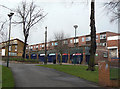
1
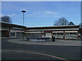
Closed shops on The Chase, Nottingham
This was 3pm on a Saturday afternoon, but all these shops including the supermarket and former post office were shut, which suggests they are no longer in business. The supermarket used to be a Co-Op, see Image
Image: © Stephen Craven
Taken: 18 Jan 2020
0.02 miles
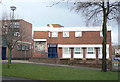
2
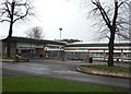
Robin Hood Chase Centre
The upper set of shops, including Library (far left), supermarket and Post Office.
Image: © Alan Murray-Rust
Taken: 8 Mar 2009
0.02 miles
3
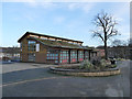
The Chase Neighbourhood Centre
The 'green' (sedum) roof suggests a date later than the 1970s of the surrounding buildings.
Image: © Stephen Craven
Taken: 18 Jan 2020
0.03 miles
4
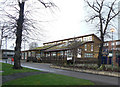
The Chase Centre
Community Centre for St Anns.
A modern building - note the deliberately vegetated roof.
Image: © Alan Murray-Rust
Taken: 8 Mar 2009
0.04 miles
5
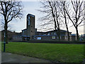
Church of St Ann with Emmanuel, Nottingham
The original St Ann's church, which was on St Ann's Well Road, opened in 1864, succeeding an earlier mission chapel. It closed at Easter 1971 and the present building opened the following year (source: http://southwellchurches.nottingham.ac.uk/nottingham-st-ann/hhistory.php ). Emmanuel church on Woodborough Road closed about the same time and the new church took both names (from Wikipedia).
The architect was probably Gordon Smith, who certainly designed other churches in similar style at this period, and is still recorded on the Church Heritage Record as the inspecting architect for St Ann's.
Image: © Stephen Craven
Taken: 18 Jan 2020
0.05 miles
6
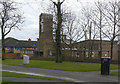
Parish Church of St Ann and Emmanuel
Anglican parish church built as part of the redevelopment of the St Anns area and opened in 1974. On Robin Hood Chase.
Image: © Alan Murray-Rust
Taken: 8 Mar 2009
0.06 miles
7
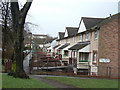
Tulip Avenue
Part of the St Anns redevelopment of the early 1970s.
Image: © Alan Murray-Rust
Taken: 8 Mar 2009
0.06 miles
8
Shops at Robin Hood Chase
This is the main commercial centre of the St Anns area.
Image: © Alan Murray-Rust
Taken: 8 Mar 2009
0.06 miles
9
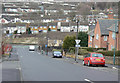
Looking down Southampton Street
Until the 1960s, St Anns was a warren of densely packed terraced housing from the first half of the 19th century. This was all swept away in a major redevelopment from the late 1960s onwards.
Image: © Alan Murray-Rust
Taken: 8 Mar 2009
0.06 miles
10
The Chase
1970s pub at the foot of Robin Hood Chase.
Image: © Alan Murray-Rust
Taken: 8 Mar 2009
0.07 miles