IMAGES TAKEN NEAR TO
Fen Road, SLEAFORD, NG34 9TQ
Introduction
This page details the photographs taken nearby to Fen Road, NG34 9TQ by members of the Geograph project.
The Geograph project started in 2005 with the aim of publishing, organising and preserving representative images for every square kilometre of Great Britain, Ireland and the Isle of Man.

There are currently over 7.5m images from over14,400 individuals and you can help contribute to the project by visiting https://www.geograph.org.uk
Image Map
Images are licensed for reuse under creativecommons.org/licenses/by-sa/2.0
Notes
- Clicking on the map will re-center to the selected point.
- The higher the marker number, the further away the image location is from the centre of the postcode.
Image Listing (20 Images Found)
Images are licensed for reuse under creativecommons.org/licenses/by-sa/2.0
Image
Details
Distance
1
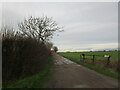
Access driveway to Wong Farm, Ruskington Fen, Anwick
Image: © Adrian S Pye
Taken: 8 Sep 2019
0.01 miles
3
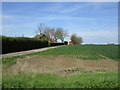
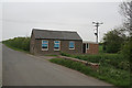
Wong Farm
Stands on slightly elevated land.
Image: © Jonathan Thacker
Taken: 4 May 2015
0.03 miles
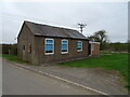
5
Ruskington Fen Wesleyan Reform Chapel
This small and exceedingly plain chapel is still in use.
Image: © Alan Murray-Rust
Taken: 29 Apr 2007
0.08 miles
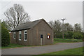
6
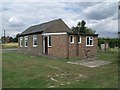
Ruskington Fen Wesleyan Reform Chapel
Image: © J.Hannan-Briggs
Taken: 14 Aug 2011
0.08 miles
7
Ruskington Fen Wesleyan Reform Chapel
This small and exceedingly plain chapel is still in use.
Image: © Alan Murray-Rust
Taken: 29 Apr 2007
0.08 miles