IMAGES TAKEN NEAR TO
Fen Road, SLEAFORD, NG34 9TG
Introduction
This page details the photographs taken nearby to Fen Road, NG34 9TG by members of the Geograph project.
The Geograph project started in 2005 with the aim of publishing, organising and preserving representative images for every square kilometre of Great Britain, Ireland and the Isle of Man.

There are currently over 7.5m images from over14,400 individuals and you can help contribute to the project by visiting https://www.geograph.org.uk
Image Map
Images are licensed for reuse under creativecommons.org/licenses/by-sa/2.0
Notes
- Clicking on the map will re-center to the selected point.
- The higher the marker number, the further away the image location is from the centre of the postcode.
Image Listing (5 Images Found)
Images are licensed for reuse under creativecommons.org/licenses/by-sa/2.0
Image
Details
Distance
1
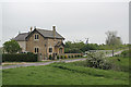
North Hills Lodge
This attractive lodge is dated 1836
Image: © Alan Murray-Rust
Taken: 29 Apr 2007
0.01 miles
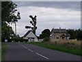
3
Ash trees near the turn by North Hills Lodge
This road has suffered as a result of a long hard winter, though sections have been resurfaced.
Image: © Chris
Taken: 8 Jun 2013
0.08 miles
4
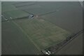
Cropmarks on field east of Ruskington: aerial 2022
Probably modern drainage (diagonal lines) and ditches from former enclosure boundaries.
Image: © Chris
Taken: 23 Jan 2022
0.13 miles
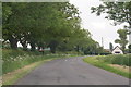
5
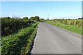
Unnamed road north of Anwick WW1 airfield
Image: © Adrian S Pye
Taken: 8 Sep 2019
0.21 miles