IMAGES TAKEN NEAR TO
Ewerby Waithe, SLEAFORD, NG34 9PS
Introduction
This page details the photographs taken nearby to NG34 9PS by members of the Geograph project.
The Geograph project started in 2005 with the aim of publishing, organising and preserving representative images for every square kilometre of Great Britain, Ireland and the Isle of Man.

There are currently over 7.5m images from over14,400 individuals and you can help contribute to the project by visiting https://www.geograph.org.uk
Image Map
Images are licensed for reuse under creativecommons.org/licenses/by-sa/2.0
Notes
- Clicking on the map will re-center to the selected point.
- The higher the marker number, the further away the image location is from the centre of the postcode.
Image Listing (7 Images Found)
Images are licensed for reuse under creativecommons.org/licenses/by-sa/2.0
Image
Details
Distance
1
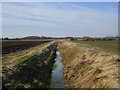
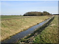
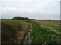
Catchwater Drain
A vital part of the drainage system in this area.
Image: © Jonathan Thacker
Taken: 6 Mar 2015
0.11 miles
3
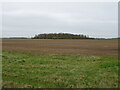
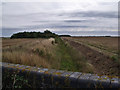
Flat farmland, Ewerby Fen
Towards a distant Fox Covert.
Image: © JThomas
Taken: 1 Apr 2021
0.17 miles
5
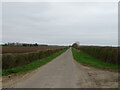
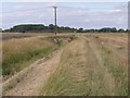
Minor road, Ewerby Fen
Towards Ewerby Waithe Common.
Image: © JThomas
Taken: 1 Apr 2021
0.20 miles