IMAGES TAKEN NEAR TO
Orchard Close, SLEAFORD, NG34 9JB
Introduction
This page details the photographs taken nearby to Orchard Close, NG34 9JB by members of the Geograph project.
The Geograph project started in 2005 with the aim of publishing, organising and preserving representative images for every square kilometre of Great Britain, Ireland and the Isle of Man.

There are currently over 7.5m images from over14,400 individuals and you can help contribute to the project by visiting https://www.geograph.org.uk
Image Map
Images are licensed for reuse under creativecommons.org/licenses/by-sa/2.0
Notes
- Clicking on the map will re-center to the selected point.
- The higher the marker number, the further away the image location is from the centre of the postcode.
Image Listing (49 Images Found)
Images are licensed for reuse under creativecommons.org/licenses/by-sa/2.0
Image
Details
Distance
1
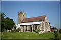
St.John the Baptist's church, Great Hale
The tower is either late Saxon or early Norman crowned with Perpendicular pinnacles, a tall Early English nave and a restoration by Hodgson Fowler in 1896-7. The chancel was destroyed during the English Civil War.
Image: © Richard Croft
Taken: 7 Jun 2006
0.06 miles
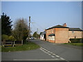
2

Hall Road
This road in Great Hale, viewed from the end of Hall Park, was closed for road works on the day of my visit.
Image: © Mary and Angus Hogg
Taken: 2 Sep 2021
0.07 miles
6
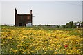
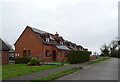
Derelict building
Derelict building off Leas Road
Image: © Richard Croft
Taken: 7 Jun 2006
0.12 miles
8
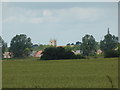
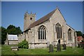
Churches in a Landscape
The eight pinnacles of the tower of St John the Baptist church, Great Hale; and beyond it the Spire of St.Andrew's church, Heckington
It is a theory of mine that one purpose of church towers, spires, and pinnacles was for navigation in the landscape as much as for the glory of God or the donors. This theory is refined by the various civic towers in Europe, which like our churches come in a huge variety of styles.
The earliest Ordnance Survey maps carefully differentiated spires from tower just for the purpose of fixing one's position.
Image: © Bob Harvey
Taken: 3 Jul 2019
0.13 miles
9
The Beck, Great Hale
Looking east from Beckstone Bridge on Little Hale Road (B1394),
Image: © JThomas
Taken: 1 Apr 2021
0.13 miles
10
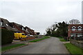
High Street, Great Hale
Seen from the end of Church Street.
Image: © Richard Vince
Taken: 22 Mar 2022
0.14 miles