IMAGES TAKEN NEAR TO
Mulberry Walk, SLEAFORD, NG34 9GW
Introduction
This page details the photographs taken nearby to Mulberry Walk, NG34 9GW by members of the Geograph project.
The Geograph project started in 2005 with the aim of publishing, organising and preserving representative images for every square kilometre of Great Britain, Ireland and the Isle of Man.

There are currently over 7.5m images from over14,400 individuals and you can help contribute to the project by visiting https://www.geograph.org.uk
Image Map
Images are licensed for reuse under creativecommons.org/licenses/by-sa/2.0
Notes
- Clicking on the map will re-center to the selected point.
- The higher the marker number, the further away the image location is from the centre of the postcode.
Image Listing (6 Images Found)
Images are licensed for reuse under creativecommons.org/licenses/by-sa/2.0
Image
Details
Distance
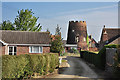
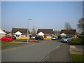
3
Potesgrave Way, Heckington
Seen from the end of Norris Close.
Image: © Richard Vince
Taken: 22 Mar 2022
0.19 miles
4
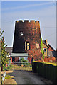
Old Mill at Heckington
Sadly overshadowed by the "other" Heckington windmill in Image
Image: © J.Hannan-Briggs
Taken: 30 Sep 2012
0.19 miles
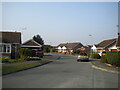
5
Norris Close, Heckington
Off Potesgrave Way.
Image: © Richard Vince
Taken: 22 Mar 2022
0.21 miles
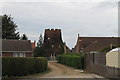
6
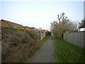
Public footpath to Godson Avenue, Heckington
Sneaking between the back gardens of houses on Osborn Way (left) and Churchill Way.
Image: © Richard Vince
Taken: 22 Mar 2022
0.21 miles