
IMAGES TAKEN NEAR TO
Manor Street, SLEAFORD, NG34 9EJ
Introduction
This page details the photographs taken nearby to Manor Street, NG34 9EJ by members of the Geograph project.
The Geograph project started in 2005 with the aim of publishing, organising and preserving representative images for every square kilometre of Great Britain, Ireland and the Isle of Man.

There are currently over 7.5m images from over14,400 individuals and you can help contribute to the project by visiting https://www.geograph.org.uk
Image Map
Images are licensed for reuse under creativecommons.org/licenses/by-sa/2.0
Notes
- Clicking on the map will re-center to the selected point.
- The higher the marker number, the further away the image location is from the centre of the postcode.
Image Listing (95 Images Found)
Images are licensed for reuse under creativecommons.org/licenses/by-sa/2.0
Image
Details
Distance
1
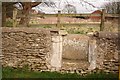
Site of Hodgson's Almshouses
Lady Anne Hodgson's will of 1719 provided almshouses for three poor women who 'behaved properly and attended church' they were demolished some time in the 19th century and the founders stone set in the base of a doorway are all that remains
Image: © Richard Croft
Taken: 23 Feb 2008
0.02 miles
2
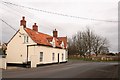
West Gate
Looking towards Pinfold Lane and the site of Hodgson's Almshouses http://www.geograph.org.uk/photo/702952
Image: © Richard Croft
Taken: 23 Feb 2008
0.03 miles
3
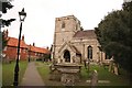
All Saints' church
All Saints has a bold Norman tower arch of the mid 12th century and once had a spire ..... the tower and spire fell down in 1618 and was rebuilt in 1620
Image: © Richard Croft
Taken: 23 Feb 2008
0.04 miles
4
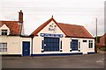
Agra 2
Popular Indian takeaway on Pinfold Lane
Image: © Richard Croft
Taken: 23 Feb 2008
0.04 miles
5
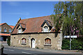
Poyntell Cottage, 2 Manor Street, Ruskington
Grade II Listed late 17th century cottage restored around 1870 and again in the 20th century. The much altered cottage has a datestone of 1669.
Image: © Jo and Steve Turner
Taken: 26 Apr 2021
0.05 miles
6
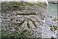
Ordnance Survey Cut Mark
This OS cut mark can be found on the north face of All Saints Church. It marks a point 12.756m above mean sea level.
Image: © Adrian Dust
Taken: 24 Jul 2017
0.05 miles
7
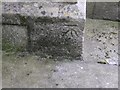
Cut Mark: Ruskington, All Saints' Church
Cut bench mark on a buttress at the north-west angle of the church tower. See http://www.bench-marks.org.uk/bm68882 for details.
Image: © Brian Westlake
Taken: 13 Jul 2015
0.05 miles
8
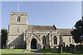
All Saints' church, Ruskington
South aspect.
Image: © Julian P Guffogg
Taken: 13 Apr 2016
0.05 miles
9
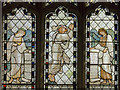
Detail of Stained glass window, All Saints' church, Ruskington
Detail of The Ascension by Morris, 1874.
Image: © Julian P Guffogg
Taken: 13 Apr 2016
0.05 miles
10

Chancel window, All Saints' church, Ruskington
In memory of John Hanwell d.1990
Glass by Celtic Studios of Swansea, designed by H.R.Thomas.
Image: © Julian P Guffogg
Taken: 13 Apr 2016
0.05 miles