IMAGES TAKEN NEAR TO
Station Road, SLEAFORD, NG34 9DE
Introduction
This page details the photographs taken nearby to Station Road, NG34 9DE by members of the Geograph project.
The Geograph project started in 2005 with the aim of publishing, organising and preserving representative images for every square kilometre of Great Britain, Ireland and the Isle of Man.

There are currently over 7.5m images from over14,400 individuals and you can help contribute to the project by visiting https://www.geograph.org.uk
Image Map
Images are licensed for reuse under creativecommons.org/licenses/by-sa/2.0
Notes
- Clicking on the map will re-center to the selected point.
- The higher the marker number, the further away the image location is from the centre of the postcode.
Image Listing (107 Images Found)
Images are licensed for reuse under creativecommons.org/licenses/by-sa/2.0
Image
Details
Distance
1
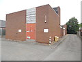
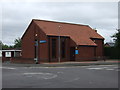
Ruskington Telephone Exchange, Lincs
Situated in Station Road, this redbrick TE is of a standard design dating from the 1970s, and would have replaced a smaller building in the same village. It has the code SLRU and provides telephone and broadband services to 2,882 residential and 96 non-residential premises in Ruskington, Anwick, Bloxholm, Dorrington and the surrounding area. Two square white BT warning notices can be seen on the front of this building and a yellow grit salt bin is to the side of it. The numbering range of this TE is (01526) 83xxxx, the (01526) referring to the Martin group of eight TEs, and its postcode is NG34 9DE.
Image: © David Hillas
Taken: 19 Jul 2019
0.02 miles
2
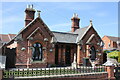
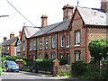
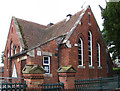
6 and 8 Jubilee Street, Ruskington
Grade II Listed pair of cottages. The ashlar kneelers are carved with 'TEATOTAL HOUSES, VICTORIA JUBILEE'. The houses were built in 1887 as almshouses for the poor of Ruskington. Jubilee Teetotal Homes is a registered charity which exists to provide housing for retired people in Ruskington. In May 1998 Longhurst and Havelok Homes Limited were appointed as sole trustee.
Image: © Jo and Steve Turner
Taken: 26 Apr 2021
0.05 miles
3
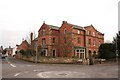
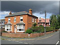
Eagle House
Eagle House was built in 1857 for the Patterson family whose construction company built stations and other railway buildings
Image: © Richard Croft
Taken: 23 Feb 2008
0.06 miles
4
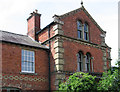
Ruskington - Eagle House brickwork detail
This view is of the Station Road side of the house. For a wider-angle view of Eagle House, please see Richard Croft's Image
Image: © Dave Bevis
Taken: 20 Jun 2012
0.07 miles
6
Ruskington, Lincolnshire
House at the corner of Station Road and Chestnut Street, Ruskington.
Image: © Malc McDonald
Taken: 11 Sep 2010
0.08 miles
8
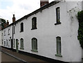
Ruskington - cottages on High Street South
Image: © Dave Bevis
Taken: 20 Jun 2012
0.08 miles
9
Ruskington - Youth Centre
On High Street South.
Image: © Dave Bevis
Taken: 20 Jun 2012
0.08 miles
10
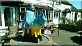
NHS Tribute
The Shoulder of Mutton Inn may be temporarily closed because of ye plague, but it still provides refreshment for the passer-by in the form of one of the Lincoln Knight's Trail statues - complete with protective clothing and facemask!
See the unmasked man on this page: https://www.wildinart.co.uk/wia-event/lincoln-knights-trail-2017/
Image: © Ian Paterson
Taken: 28 May 2020
0.09 miles