IMAGES TAKEN NEAR TO
Burton Road, SLEAFORD, NG34 9BQ
Introduction
This page details the photographs taken nearby to Burton Road, NG34 9BQ by members of the Geograph project.
The Geograph project started in 2005 with the aim of publishing, organising and preserving representative images for every square kilometre of Great Britain, Ireland and the Isle of Man.

There are currently over 7.5m images from over14,400 individuals and you can help contribute to the project by visiting https://www.geograph.org.uk
Image Map
Images are licensed for reuse under creativecommons.org/licenses/by-sa/2.0
Notes
- Clicking on the map will re-center to the selected point.
- The higher the marker number, the further away the image location is from the centre of the postcode.
Image Listing (19 Images Found)
Images are licensed for reuse under creativecommons.org/licenses/by-sa/2.0
Image
Details
Distance
4
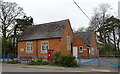
Parva House on Main Road, Little Hale
Activity and Training Centre.
Showing position of Postbox No. NG34 64.
See Image] for postbox.
Image: © JThomas
Taken: 1 Apr 2021
0.16 miles
5

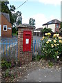
George VI postbox on Main Road, Little Hale
Postbox No. NG34 64.
See Image] for context.
Image: © JThomas
Taken: 1 Apr 2021
0.16 miles
6
Home-made pillar box
A "GR" wall box in a brick-built pillar.
See Image] for the context.
Image: © Bob Harvey
Taken: 3 Jul 2019
0.16 miles
7
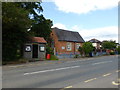
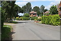
Little Hale
The former village school is now a scout hut called "Parva House". To the left of it is the village bus shelter, home to several village notice boards. One of King George's postboxes is built into a brick pillar to the right of the school.
There is an electrical substation behind the bus shelter, and a water pumphouse beyond the trees on the left. This is a tiny cluster of municipal services, all together, and I am left wondering why. In Victorian times schools were often built on Glebe land, and I wonder if the rest of that parcel of land devolved to the authorities in some way, and became the prime place to put local infrastructure.
Image: © Bob Harvey
Taken: 3 Jul 2019
0.16 miles
8
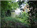
Electricity substation
This is the substation mentioned in Image It is completely behind the bus shelter in that photo.
Image: © Bob Harvey
Taken: 3 Jul 2019
0.17 miles
9
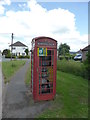
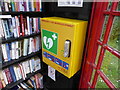
Former phone box
Telephone box adopted by the community for other uses.
Image: © Bob Harvey
Taken: 3 Jul 2019
0.17 miles