IMAGES TAKEN NEAR TO
Westcliffe Road, SLEAFORD, NG34 9AY
Introduction
This page details the photographs taken nearby to Westcliffe Road, NG34 9AY by members of the Geograph project.
The Geograph project started in 2005 with the aim of publishing, organising and preserving representative images for every square kilometre of Great Britain, Ireland and the Isle of Man.

There are currently over 7.5m images from over14,400 individuals and you can help contribute to the project by visiting https://www.geograph.org.uk
Image Map
Images are licensed for reuse under creativecommons.org/licenses/by-sa/2.0
Notes
- Clicking on the map will re-center to the selected point.
- The higher the marker number, the further away the image location is from the centre of the postcode.
Image Listing (4 Images Found)
Images are licensed for reuse under creativecommons.org/licenses/by-sa/2.0
Image
Details
Distance
2
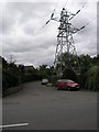
Pylons Through the Houses
To be fair to the pylons they have been there for years and it is the houses of Ruskington that have expanded out to them.
Image: © Michael Patterson
Taken: 4 Aug 2006
0.13 miles