IMAGES TAKEN NEAR TO
Hine Avenue, NG34 8ZW
Introduction
This page details the photographs taken nearby to Hine Avenue, NG34 8ZW by members of the Geograph project.
The Geograph project started in 2005 with the aim of publishing, organising and preserving representative images for every square kilometre of Great Britain, Ireland and the Isle of Man.

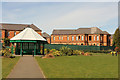
There are currently over 7.5m images from over14,400 individuals and you can help contribute to the project by visiting https://www.geograph.org.uk
Image Map
Images are licensed for reuse under creativecommons.org/licenses/by-sa/2.0
Notes
- Clicking on the map will re-center to the selected point.
- The higher the marker number, the further away the image location is from the centre of the postcode.
Image Listing (32 Images Found)
Images are licensed for reuse under creativecommons.org/licenses/by-sa/2.0
Image
Details
Distance
1
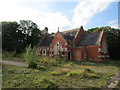
Former Rauceby Hospital Chapel
Rauceby Hospital was opened as the Kesteven County Asylum in 1902. It closed in 1997. Most of the site has been redeveloped for housing and is known as Greylees. However most of the hospital buildings remain though in a derelict state. They were designed by G.T. Hine https://en.wikipedia.org/wiki/George_Thomas_Hine
Image: © Jonathan Thacker
Taken: 24 Aug 2020
0.01 miles
2
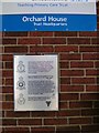
Guinea Pig Club Plaque, South Rauceby, Lincs
1940's Pioneering Plastic Surgery Plaque at Orchard House, Sleaford, South Rauceby.
Image: © Vivien Hughes
Taken: 11 Sep 2009
0.05 miles
3
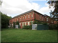
Former Rauceby Hospital building
Now derelict and isolated within the housing development known as Greylees. https://en.wikipedia.org/wiki/Rauceby_Hospital
Image: © Jonathan Thacker
Taken: 24 Aug 2020
0.05 miles
4
Former Rauceby Hospital
Rauceby Hospital was opened as the Kesteven County Asylum in 1902. It closed in 1997. Most of the site has been redeveloped for housing and is known as Greylees. However most of the hospital buildings remain though in a derelict state. They were designed by G.T. Hine https://en.wikipedia.org/wiki/George_Thomas_Hine
Image: © Jonathan Thacker
Taken: 24 Aug 2020
0.09 miles
5
Former Rauceby Hospital
Derelict buildings of the former Rauceby Hospital and gazebo in a park at Greylees http://www.geograph.org.uk/photo/4413351
Image: © Richard Croft
Taken: 2 Apr 2015
0.10 miles
6
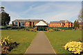
Greylees park & Rauceby Hospital
Park at Greylees and derelict buildings of the old Rauceby Hospital beyond
Image: © Richard Croft
Taken: 2 Apr 2015
0.11 miles
7
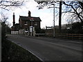
Rauceby Station
Rauceby Station appears to be one of those stations that was somehow (and thankfully) overlooked during the Beeching era. The gates are wooden and swing across the road/line on hinges and the level crossing is made from timber. No doubt the lamps on it are powered by oil!
Image: © Michael Patterson
Taken: 15 Feb 2006
0.14 miles
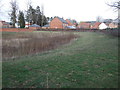
8
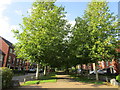
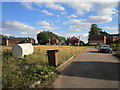
Avenue at Greylees
Greylees is a housing development on the site of the former Rauceby Hospital https://en.wikipedia.org/wiki/Rauceby_Hospital
Image: © Jonathan Thacker
Taken: 24 Aug 2020
0.17 miles
10
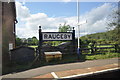
Rauceby Station Sign
The period station sign on this lovely little Lincolnshire line.
Image: © Ashley Dace
Taken: 28 May 2011
0.18 miles