IMAGES TAKEN NEAR TO
The Garth, SLEAFORD, NG34 8YG
Introduction
This page details the photographs taken nearby to The Garth, NG34 8YG by members of the Geograph project.
The Geograph project started in 2005 with the aim of publishing, organising and preserving representative images for every square kilometre of Great Britain, Ireland and the Isle of Man.

There are currently over 7.5m images from over14,400 individuals and you can help contribute to the project by visiting https://www.geograph.org.uk
Image Map
Images are licensed for reuse under creativecommons.org/licenses/by-sa/2.0
Notes
- Clicking on the map will re-center to the selected point.
- The higher the marker number, the further away the image location is from the centre of the postcode.
Image Listing (40 Images Found)
Images are licensed for reuse under creativecommons.org/licenses/by-sa/2.0
Image
Details
Distance
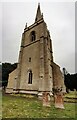
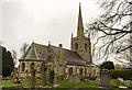
1
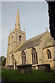
St Botolph's Church, Quarrington, Lincolnshire
The parish church of St Botolph, Quarrington, Lincolnshire
Image: © Gary Brothwell
Taken: 1 Sep 2010
0.14 miles
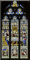
3

Chancel Stained glass window, St Botolph's church, Quarrington
Crucifixion scene by Ward & Hughes, 1862.
Image: © Julian P Guffogg
Taken: 18 Mar 2020
0.15 miles
4
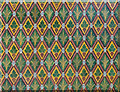
Tiles in the chancel, Quarrington church
Dating from 1862.
Image: © Julian P Guffogg
Taken: 18 Mar 2020
0.15 miles
5
Gould window, St Botolph's church, Quarrington
Depicting The Good Samaritan and in memory of John Gould d.1914.
Glass is by Ward & Hughes.
Image: © Julian P Guffogg
Taken: 18 Mar 2020
0.15 miles
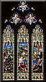
6
Stained glass window, St Botolph's church, Quarrington
Depicting The Last Supper. The predella shows Melchisedek bringing bread and wine to Abram, The Resurrection, and Supper at Emmaus.
Glass is probably by Burlison & Grylls in memory of Rev. Benjamin Shaul, C.1930.
Image: © Julian P Guffogg
Taken: 18 Mar 2020
0.15 miles
7
St Botolph's Church and churchyard
There is an Ordnance Survey benchmark Image at the base of the left hand buttress on the right hand corner of the tower.
The spire is an OS intersected station trig point with its grid reference TF 05400 44467 computed on 1/6/1950, https://trigpointing.uk/trig/13476
Image: © Roger Templeman
Taken: 27 Jun 2023
0.16 miles
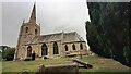
8
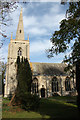
St.Botolph's church
Largely 13th & 14th century with a Victorian chancel of 1862 and some unusual plate tracery in the south windows, most likely from the 1862 restoration.
Image: © Richard Croft
Taken: 24 Oct 2011
0.16 miles
9
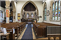
St Botolph's church, Quarrington, interior
Looking east up the nave.
Image: © Julian P Guffogg
Taken: 18 Mar 2020
0.16 miles
10
St Botolph's church, Quarrington
View from the north east.
Image: © Julian P Guffogg
Taken: 18 Mar 2020
0.16 miles