IMAGES TAKEN NEAR TO
Montrose Grove, SLEAFORD, NG34 8XZ
Introduction
This page details the photographs taken nearby to Montrose Grove, NG34 8XZ by members of the Geograph project.
The Geograph project started in 2005 with the aim of publishing, organising and preserving representative images for every square kilometre of Great Britain, Ireland and the Isle of Man.

There are currently over 7.5m images from over14,400 individuals and you can help contribute to the project by visiting https://www.geograph.org.uk
Image Map
Images are licensed for reuse under creativecommons.org/licenses/by-sa/2.0
Notes
- Clicking on the map will re-center to the selected point.
- The higher the marker number, the further away the image location is from the centre of the postcode.
Image Listing (15 Images Found)
Images are licensed for reuse under creativecommons.org/licenses/by-sa/2.0
Image
Details
Distance
1
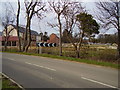
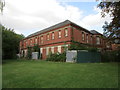
Rauceby Hospital site
Rauceby Hospital was a large mental hospital close to Sleaford, Lincolnshire, and was originally called Kesteven County Asylum.
The Asylum, which started in 1894, but didn't open until 1897. The grounds covered some 115 acres. Construction finished in 1902 and opened in June of that year to patients.
The hospital was taken over by the RAF in June 1940 as No.4 RAF Hospital Rauceby - a Crash and Burns Unit for the pilots in Lincolnshire. Existing patients were transferred to neighbouring institutions. RAF Cranwell's medical unit ran the hospital.
There are two grave yards, opposite the old staff houses to the rear of the hospital. Most of the stones were moved to the sides in the 1960s.
The hospital closed in 1997 and stood unused for several years. It was featured on Restoration Nation as a showcase of these types of building and what happens to them when they fall into disuse.
New homes are now being built but the locations is now "Devessey Meadows" Willoughby Road, Greylees, Lincolnshire. With 2,4,5 and 6 bedroom homes from £123,995
Image: © Ken Brockway
Taken: 10 Mar 2007
0.04 miles
2
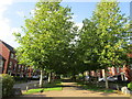
Avenue at Greylees
Greylees is a housing development on the site of the former Rauceby Hospital https://en.wikipedia.org/wiki/Rauceby_Hospital
Image: © Jonathan Thacker
Taken: 24 Aug 2020
0.07 miles
3
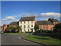
Renfrew Drive, Greylees
Built on the grounds of the former Rauceby Hospital.
Image: © Jonathan Thacker
Taken: 24 Aug 2020
0.08 miles
4
Former Rauceby Hospital
Rauceby Hospital was opened as the Kesteven County Asylum in 1902. It closed in 1997. Most of the site has been redeveloped for housing and is known as Greylees. However most of the hospital buildings remain though in a derelict state. They were designed by G.T. Hine https://en.wikipedia.org/wiki/George_Thomas_Hine
Image: © Jonathan Thacker
Taken: 24 Aug 2020
0.12 miles
5
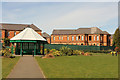
Former Rauceby Hospital
Derelict buildings of the former Rauceby Hospital and gazebo in a park at Greylees http://www.geograph.org.uk/photo/4413351
Image: © Richard Croft
Taken: 2 Apr 2015
0.14 miles
6
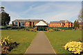
Greylees park & Rauceby Hospital
Park at Greylees and derelict buildings of the old Rauceby Hospital beyond
Image: © Richard Croft
Taken: 2 Apr 2015
0.15 miles
7
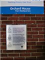
Guinea Pig Club Plaque, South Rauceby, Lincs
1940's Pioneering Plastic Surgery Plaque at Orchard House, Sleaford, South Rauceby.
Image: © Vivien Hughes
Taken: 11 Sep 2009
0.17 miles
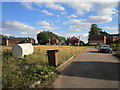
8
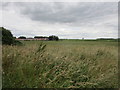
View towards Greylees
Greylees is an expanding settlement built on the site of the former Rauceby Hospital.
Image: © Jonathan Thacker
Taken: 2 Jul 2019
0.17 miles
9
Former Rauceby Hospital building
Now derelict and isolated within the housing development known as Greylees. https://en.wikipedia.org/wiki/Rauceby_Hospital
Image: © Jonathan Thacker
Taken: 24 Aug 2020
0.21 miles
10
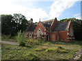
Former Rauceby Hospital Chapel
Rauceby Hospital was opened as the Kesteven County Asylum in 1902. It closed in 1997. Most of the site has been redeveloped for housing and is known as Greylees. However most of the hospital buildings remain though in a derelict state. They were designed by G.T. Hine https://en.wikipedia.org/wiki/George_Thomas_Hine
Image: © Jonathan Thacker
Taken: 24 Aug 2020
0.21 miles