IMAGES TAKEN NEAR TO
Rudkin Drive, SLEAFORD, NG34 8TS
Introduction
This page details the photographs taken nearby to Rudkin Drive, NG34 8TS by members of the Geograph project.
The Geograph project started in 2005 with the aim of publishing, organising and preserving representative images for every square kilometre of Great Britain, Ireland and the Isle of Man.

There are currently over 7.5m images from over14,400 individuals and you can help contribute to the project by visiting https://www.geograph.org.uk
Image Map
Images are licensed for reuse under creativecommons.org/licenses/by-sa/2.0
Notes
- Clicking on the map will re-center to the selected point.
- The higher the marker number, the further away the image location is from the centre of the postcode.
Image Listing (5 Images Found)
Images are licensed for reuse under creativecommons.org/licenses/by-sa/2.0
Image
Details
Distance
1
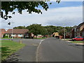
Woodside Avenue Sleaford
Sleaford Wood can be seen at the end of the avenue.
Image: © Mick Lobb
Taken: 2 Sep 2008
0.06 miles
2
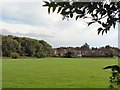
Across playing field to Beech Rise and Sleaford Wood
Image: © Mick Lobb
Taken: 2 Sep 2008
0.10 miles
3

Footpath to Leasingham from Holdingham at Northfield
Image: © Mick Lobb
Taken: 2 Sep 2008
0.19 miles
4
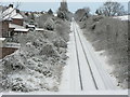
Main line , Sleaford.
From the Galley Hill Bridge on Lincoln Road.
Image: © Mick Lobb
Taken: 28 Dec 2005
0.23 miles
5
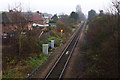
Railway west of Sleaford North Junction
This stretch of railway connects Sleaford West Junction with Sleaford North Junction and is used by passenger trains on the Great Northern and Great Eastern Joint Line (between Spalding and Lincoln) that call at Sleaford station. Freight trains use an avoiding line.
Image: © Stephen McKay
Taken: 13 Dec 2015
0.25 miles