IMAGES TAKEN NEAR TO
Swarby, SLEAFORD, NG34 8TJ
Introduction
This page details the photographs taken nearby to NG34 8TJ by members of the Geograph project.
The Geograph project started in 2005 with the aim of publishing, organising and preserving representative images for every square kilometre of Great Britain, Ireland and the Isle of Man.

There are currently over 7.5m images from over14,400 individuals and you can help contribute to the project by visiting https://www.geograph.org.uk
Image Map
Images are licensed for reuse under creativecommons.org/licenses/by-sa/2.0
Notes
- Clicking on the map will re-center to the selected point.
- The higher the marker number, the further away the image location is from the centre of the postcode.
Image Listing (14 Images Found)
Images are licensed for reuse under creativecommons.org/licenses/by-sa/2.0
Image
Details
Distance
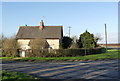
1
Harts Lodge
Harts (male red deer) Lodge at road and footpath intersection.
Image: © Ken Brockway
Taken: 10 Mar 2007
0.01 miles
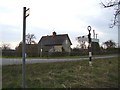
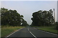
2
Hart's Lodge, Swarby
At the junction of Swarby Lane and the A15.
Image: © Alan Murray-Rust
Taken: 24 Dec 2014
0.02 miles
3
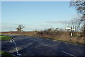
Swarby turn on the A15
The junction retains a traditional cast-iron fingerpost http://www.geograph.org.uk/photo/4291380
Image: © Alan Murray-Rust
Taken: 24 Dec 2014
0.03 miles
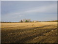
4
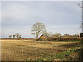
Corner of a stubble field near Hart's Lodge
Heavy rain from September through to December has resulted in many fields that would normally have been ploughed and sown in the autumn remain as stubble.
Image: © Jonathan Thacker
Taken: 16 Jan 2020
0.03 miles
6
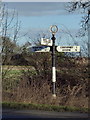
Fingerpost at Swarby turn
Very unusually for a trunk road, there are no Worboys-pattern direction signs at this junction. The finial carries the initials of Kesteven County Council.
Image: © Alan Murray-Rust
Taken: 24 Dec 2014
0.04 miles
7
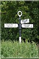
Direction Sign - Signpost by the A15 by Hart's Lodge
Annulus finial - 3 arms; Kesteven CC halo by the A15, in parish of Aswarby and Swarby (North Kesteven District), A15 junction with Swarby Lane, on verge, East side of road.
Surveyed
Milestone Society National ID: LI_TF0540
Image: © Milestone Society
Taken: Unknown
0.05 miles
8
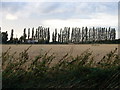
Poplar view
View of the fine poplars from the road to Swarby.
Image: © Ian Paterson
Taken: 3 Sep 2009
0.13 miles
9
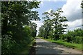
Swarby Lane leading to Swarby off the A15
Image: © Tim Heaton
Taken: 22 Jun 2023
0.14 miles
10
Stubble field and houses on Back Lane, Swarby
Image: © Jonathan Thacker
Taken: 16 Jan 2020
0.16 miles