IMAGES TAKEN NEAR TO
Swarby, SLEAFORD, NG34 8TH
Introduction
This page details the photographs taken nearby to NG34 8TH by members of the Geograph project.
The Geograph project started in 2005 with the aim of publishing, organising and preserving representative images for every square kilometre of Great Britain, Ireland and the Isle of Man.

There are currently over 7.5m images from over14,400 individuals and you can help contribute to the project by visiting https://www.geograph.org.uk
Image Map
Images are licensed for reuse under creativecommons.org/licenses/by-sa/2.0
Notes
- Clicking on the map will re-center to the selected point.
- The higher the marker number, the further away the image location is from the centre of the postcode.
Image Listing (37 Images Found)
Images are licensed for reuse under creativecommons.org/licenses/by-sa/2.0
Image
Details
Distance
1
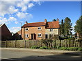
Cottages opposite the church, Swarby
One of brick and one of local stone.
Image: © Jonathan Thacker
Taken: 2 Mar 2017
0.04 miles
2
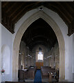
St Mary and All Saints' church, Chancel Arch
The view from the Altar, looking through the chancel arch into the nave
Image: © Bob Harvey
Taken: 16 Jan 2022
0.05 miles
3
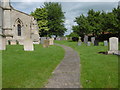
St Mary and All Saints Churchyard, Swarby
The fine Perpendicular west tower is first seen across the fields before the village is reached. John Harris in The Buildings of England: Lincolnshire describes the bell-openings as very strange. The chancel is Early English, the north arcade Decorated and the south arcade is Perpendicular. See http://www.geograph.org.uk/photo/5001244
Image: © Marathon
Taken: 18 Jun 2016
0.06 miles
4
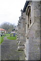
St Mary and All Saints' church, A row of buttresses
The south side of the church.
Image: © Bob Harvey
Taken: 16 Jan 2022
0.06 miles
5
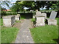
St Mary and All Saints Churchyard, Swarby
The fine Perpendicular west tower is first seen across the fields before the village is reached - see http://www.geograph.org.uk/photo/5001244 Beyond the churchyard, as can be seen here, one is soon out into fields. The churchyard has some interesting tombs.
Image: © Marathon
Taken: 18 Jun 2016
0.06 miles
6
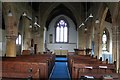
Interior, St Mary and All Saints' church, Swarby
See Image
Image: © J.Hannan-Briggs
Taken: 1 Apr 2012
0.06 miles
7

St Mary's and All Saints, Swarby
The Church dates from the 13th Century. The 15th C. West tower is of 3 stages, but the tower arch is 13th C. as is the north nave arcade with octagonal piers.
Restored 1886-7 and the south aisle added in 1886.
Image: © J.Hannan-Briggs
Taken: 1 Apr 2012
0.06 miles
8

Tombs in St Mary and All Saints Churchyard, Swarby
The fine Perpendicular west tower is first seen across the fields before the village is reached - see http://www.geograph.org.uk/photo/5001244 The churchyard has some interesting tombs like these ones in the corner of the tower and the south aisle.
Image: © Marathon
Taken: 18 Jun 2016
0.06 miles
9
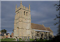
St Mary and All Saints' church, Swarby
A lovely grade II* church in the low sunlight of a winter afternoon.
See https://historicengland.org.uk/listing/the-list/list-entry/1147542.
Image: © Bob Harvey
Taken: 16 Jan 2022
0.06 miles
10

St Mary and All Saints' church, The Font
Bric-a-brac surrounds the font, as these are items offered for sale to support the work of the church.
Image: © Bob Harvey
Taken: 16 Jan 2022
0.06 miles