IMAGES TAKEN NEAR TO
East Road, SLEAFORD, NG34 8SP
Introduction
This page details the photographs taken nearby to East Road, NG34 8SP by members of the Geograph project.
The Geograph project started in 2005 with the aim of publishing, organising and preserving representative images for every square kilometre of Great Britain, Ireland and the Isle of Man.

There are currently over 7.5m images from over14,400 individuals and you can help contribute to the project by visiting https://www.geograph.org.uk
Image Map
Images are licensed for reuse under creativecommons.org/licenses/by-sa/2.0
Notes
- Clicking on the map will re-center to the selected point.
- The higher the marker number, the further away the image location is from the centre of the postcode.
Image Listing (14 Images Found)
Images are licensed for reuse under creativecommons.org/licenses/by-sa/2.0
Image
Details
Distance
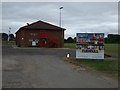
3
Sleaford Rugby Club Entrance
Very sophisticated for a sports ground, separate in and out with flower containers. The usual affair is a long single track with a tiny car park at the end. This is a splendid facility.
Image: © Michael Trolove
Taken: 11 Jan 2009
0.11 miles
4
Sleaford Rugby Club
Towards the club house.
Image: © Michael Trolove
Taken: 11 Jan 2009
0.12 miles
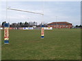
5
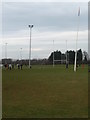
Bit Of A Lean At Sleaford RFC
The prevailing wind has had an effect on the posts and the floodlight upright.
Image: © Michael Trolove
Taken: 11 Jan 2009
0.16 miles
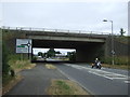
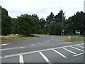
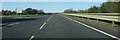
7
A17 at Bone Mill Junction, north of Sleaford
Image: © Colin Pyle
Taken: 5 Aug 2013
0.18 miles
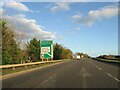
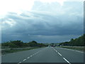
10
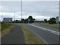
East Road (A153)
Heading south into Sleaford.
Image: © JThomas
Taken: 20 Jul 2013
0.22 miles