IMAGES TAKEN NEAR TO
Leasingham Moor, SLEAFORD, NG34 8SL
Introduction
This page details the photographs taken nearby to NG34 8SL by members of the Geograph project.
The Geograph project started in 2005 with the aim of publishing, organising and preserving representative images for every square kilometre of Great Britain, Ireland and the Isle of Man.

There are currently over 7.5m images from over14,400 individuals and you can help contribute to the project by visiting https://www.geograph.org.uk
Image Map
Images are licensed for reuse under creativecommons.org/licenses/by-sa/2.0
Notes
- Clicking on the map will re-center to the selected point.
- The higher the marker number, the further away the image location is from the centre of the postcode.
Image Listing (4 Images Found)
Images are licensed for reuse under creativecommons.org/licenses/by-sa/2.0
Image
Details
Distance
2
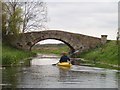
Bridge by White House
Bridge over the river Slea next to a white house
Image: © Jim Thornton
Taken: 26 Feb 2006
0.14 miles
3
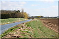
Bridge by White House on the River Slea
Bridge over the former Slea Navigation
Image: © Tony Clayton
Taken: 14 Apr 2006
0.14 miles
4
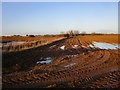
Drain and waterlogged field off Moor Lane, Leasingham
Image: © Jonathan Thacker
Taken: 14 Dec 2019
0.22 miles