IMAGES TAKEN NEAR TO
Moor Lane, SLEAFORD, NG34 8SJ
Introduction
This page details the photographs taken nearby to Moor Lane, NG34 8SJ by members of the Geograph project.
The Geograph project started in 2005 with the aim of publishing, organising and preserving representative images for every square kilometre of Great Britain, Ireland and the Isle of Man.

There are currently over 7.5m images from over14,400 individuals and you can help contribute to the project by visiting https://www.geograph.org.uk
Image Map
Images are licensed for reuse under creativecommons.org/licenses/by-sa/2.0
Notes
- Clicking on the map will re-center to the selected point.
- The higher the marker number, the further away the image location is from the centre of the postcode.
Image Listing (10 Images Found)
Images are licensed for reuse under creativecommons.org/licenses/by-sa/2.0
Image
Details
Distance
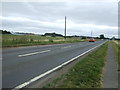
1
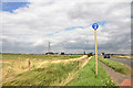
Junction with the A153 south of Ruskington
Image: © Mick Lobb
Taken: 17 Aug 2009
0.03 miles
3
Footbridge and footpath off Moor Lane
Image: © J.Hannan-Briggs
Taken: 19 May 2012
0.04 miles
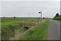
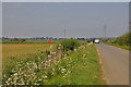
6
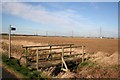
Footbridge on Moor Lane
Footbridge over the drain where the footpath leaves Moor Lane for Ruskington
Image: © Richard Croft
Taken: 4 Feb 2008
0.08 miles
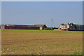
8
Footpath to Ruskington
Field path past Moor Farm and onwards to Ruskington
Image: © Richard Croft
Taken: 4 Feb 2008
0.16 miles
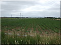
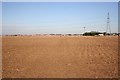
9
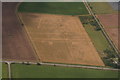
Cropmarks on field west of A153 north of Sleaford: aerial 2020 (1)
Image: © Chris
Taken: 26 Jul 2020
0.17 miles
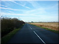
10
Papermill Lane at its junction with the A153
Image: © Mick Lobb
Taken: 18 May 2010
0.25 miles