IMAGES TAKEN NEAR TO
Westcliffe, SLEAFORD, NG34 8RF
Introduction
This page details the photographs taken nearby to NG34 8RF by members of the Geograph project.
The Geograph project started in 2005 with the aim of publishing, organising and preserving representative images for every square kilometre of Great Britain, Ireland and the Isle of Man.

There are currently over 7.5m images from over14,400 individuals and you can help contribute to the project by visiting https://www.geograph.org.uk
Image Map
Images are licensed for reuse under creativecommons.org/licenses/by-sa/2.0
Notes
- Clicking on the map will re-center to the selected point.
- The higher the marker number, the further away the image location is from the centre of the postcode.
Image Listing (12 Images Found)
Images are licensed for reuse under creativecommons.org/licenses/by-sa/2.0
Image
Details
Distance
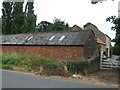
1
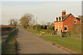
Peacock Farm
Lane to Bloxholm at Peacock Farm
Image: © Richard Croft
Taken: 2 Apr 2015
0.01 miles
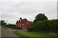
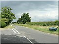
3

The Cottage
At the dog-leg junction. For Ruskington turn right then left into Westcliffe Road.
Image: © Chris
Taken: 8 Jun 2013
0.15 miles
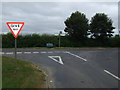
6
Grit bin at the T junction
And a spot height of 23 metres. Where the road towards Brauncewell heads west from the Leasingham - Bloxholm Road.
Image: © Christine Johnstone
Taken: 3 Jul 2022
0.16 miles
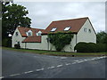
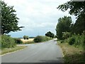
7
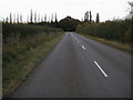
Westcliffe Road
Westcliffe Road nearing T junction by Roxholm Grange
Image: © Shaun Ferguson
Taken: 12 Oct 2009
0.17 miles
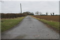
10
Grit bin at the Westcliffe Road junction
Looking south on the Bloxholm - Leasingham road.
Image: © Christine Johnstone
Taken: 3 Jul 2022
0.20 miles