IMAGES TAKEN NEAR TO
Tom Lane, SLEAFORD, NG34 8QW
Introduction
This page details the photographs taken nearby to Tom Lane, NG34 8QW by members of the Geograph project.
The Geograph project started in 2005 with the aim of publishing, organising and preserving representative images for every square kilometre of Great Britain, Ireland and the Isle of Man.

There are currently over 7.5m images from over14,400 individuals and you can help contribute to the project by visiting https://www.geograph.org.uk
Image Map
Images are licensed for reuse under creativecommons.org/licenses/by-sa/2.0
Notes
- Clicking on the map will re-center to the selected point.
- The higher the marker number, the further away the image location is from the centre of the postcode.
Image Listing (65 Images Found)
Images are licensed for reuse under creativecommons.org/licenses/by-sa/2.0
Image
Details
Distance
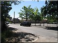
2
Field opposite the church, North Rauceby
Image: © Jonathan Thacker
Taken: 27 Mar 2015
0.10 miles
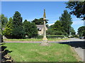
3
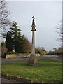
Old preaching cross (restored) North Rauceby
Image: © Adrian S Pye
Taken: 19 Nov 2017
0.12 miles
5
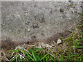
Rivet Benchmark North Rauceby Village Cross
The rivet is on the edge of the bottom step which is now level with the surrounding grass so there is possibly a set of buried arrow cuts below the edge. See http://www.geograph.org.uk/photo/5939957 for a wider view and https://www.bench-marks.org.uk/bm100835 for details.
Image: © Brian Westlake
Taken: 11 Oct 2018
0.12 miles
6
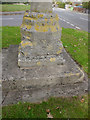
Base of the Village Cross
The bottom step (no longer!) carries a rivet bench mark. See http://www.geograph.org.uk/photo/5939938 for a close-up and https://www.bench-marks.org.uk/bm100835 for details.
Image: © Brian Westlake
Taken: 11 Oct 2018
0.12 miles
8
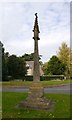
Old Central Cross in North Rauceby
Rauceby Cross, old shaft, base and steps in a new cross, by the wayside, in parish of North Rauceby (North Kesteven District), The Green, opposite Ummington.
Grade II listed. List Entry Number: 1360607
https://historicengland.org.uk/listing/the-list/list-entry/1360607
Scheduled Monument. List Entry Number: 1009231
https://historicengland.org.uk/listing/the-list/list-entry/1009231
To be surveyed
Milestone Society National ID: LINK_NRA.
Image: © Milestone Society
Taken: Unknown
0.13 miles
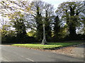
9
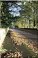
Church Lane
Autumnal scene on Church Lane, North Rauceby
Image: © Richard Croft
Taken: 11 Nov 2010
0.13 miles
10
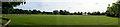
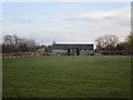
Panorama of field opposite church
This is the field opposite the church, and there appears to be some sort of sunken track across the middle aligning with the path through the church's gate.
I have no idea if this is an ancient relic or not.
This is also the field behind Image
Image: © Bob Harvey
Taken: 6 Oct 2017
0.13 miles