IMAGES TAKEN NEAR TO
Church Lane, SLEAFORD, NG34 8QU
Introduction
This page details the photographs taken nearby to Church Lane, NG34 8QU by members of the Geograph project.
The Geograph project started in 2005 with the aim of publishing, organising and preserving representative images for every square kilometre of Great Britain, Ireland and the Isle of Man.

There are currently over 7.5m images from over14,400 individuals and you can help contribute to the project by visiting https://www.geograph.org.uk
Image Map
Images are licensed for reuse under creativecommons.org/licenses/by-sa/2.0
Notes
- Clicking on the map will re-center to the selected point.
- The higher the marker number, the further away the image location is from the centre of the postcode.
Image Listing (12 Images Found)
Images are licensed for reuse under creativecommons.org/licenses/by-sa/2.0
Image
Details
Distance
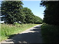
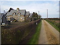
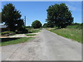
3
Restricted Byway
Off Church lane Restricted Byway down to Glebe Farm
Image: © Shaun Ferguson
Taken: 12 Oct 2009
0.05 miles
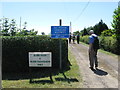
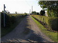
9
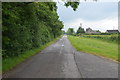
Church Lane
North Rauceby church spire can be seen in the distance.
Image: © Julian P Guffogg
Taken: 14 Jun 2015
0.18 miles