IMAGES TAKEN NEAR TO
North Rauceby, SLEAFORD, NG34 8QR
Introduction
This page details the photographs taken nearby to NG34 8QR by members of the Geograph project.
The Geograph project started in 2005 with the aim of publishing, organising and preserving representative images for every square kilometre of Great Britain, Ireland and the Isle of Man.

There are currently over 7.5m images from over14,400 individuals and you can help contribute to the project by visiting https://www.geograph.org.uk
Image Map
Images are licensed for reuse under creativecommons.org/licenses/by-sa/2.0
Notes
- Clicking on the map will re-center to the selected point.
- The higher the marker number, the further away the image location is from the centre of the postcode.
Image Listing (13 Images Found)
Images are licensed for reuse under creativecommons.org/licenses/by-sa/2.0
Image
Details
Distance
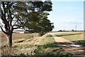
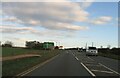
1
A17 Horizon
The A17 runs along the horizon with Cranwell just beyond.
Image: © Michael Patterson
Taken: 15 Feb 2006
0.01 miles
2
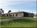
Cranwell Aviation Heritage Centre
A small but interesting museum with everything from the early Airships through Frank Whittle's contribution to the very latest Airlander 10.
Image: © Adrian S Pye
Taken: 19 Nov 2017
0.03 miles
3
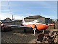
Jet Provost T Mk.4 XP556
The aircraft was in the service of the RAF at Cranwell in 1962 and was retired in 1989. It has been on display at the Cranwell Aviation Heritage Centre since April 1977.
Image: © Adrian S Pye
Taken: 19 Nov 2017
0.03 miles
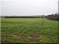
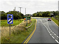
4
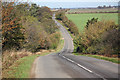
Rauceby Hill
Downhill to the A17 from North Rauceby
Image: © Richard Croft
Taken: 20 Oct 2011
0.10 miles