IMAGES TAKEN NEAR TO
Pinfold Lane, SLEAFORD, NG34 8QE
Introduction
This page details the photographs taken nearby to Pinfold Lane, NG34 8QE by members of the Geograph project.
The Geograph project started in 2005 with the aim of publishing, organising and preserving representative images for every square kilometre of Great Britain, Ireland and the Isle of Man.

There are currently over 7.5m images from over14,400 individuals and you can help contribute to the project by visiting https://www.geograph.org.uk
Image Map
Images are licensed for reuse under creativecommons.org/licenses/by-sa/2.0
Notes
- Clicking on the map will re-center to the selected point.
- The higher the marker number, the further away the image location is from the centre of the postcode.
Image Listing (20 Images Found)
Images are licensed for reuse under creativecommons.org/licenses/by-sa/2.0
Image
Details
Distance
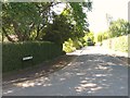
4
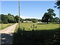
Driveway to Hall Farm
Not a public right of way but there is permissive access.
Image: © Jonathan Thacker
Taken: 20 Oct 2017
0.09 miles
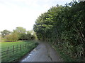
5
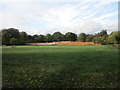
Walled garden, South Rauceby
Associated with Rauceby Hall but some distance from the house.
Image: © Jonathan Thacker
Taken: 20 Oct 2017
0.10 miles
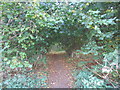
6
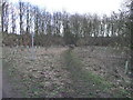
Footpath To Quarrington
This footpath leads from South Rauceby through a small copse and over the fields to Quarrington.
Image: © Michael Patterson
Taken: 15 Feb 2006
0.10 miles
9
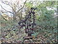
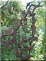
Steel sculpture in Southgate Spinney
By Richard Farrington. Entitled "In the Field". It has representations of local fauna and human activities.
Image: © Jonathan Thacker
Taken: 20 Oct 2017
0.14 miles
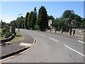
10
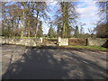
Cattle Grid Access
This access gate to Rauceby Hall is protected by a cattle grid.
Image: © Michael Patterson
Taken: 15 Feb 2006
0.17 miles