IMAGES TAKEN NEAR TO
Beech Rise, SLEAFORD, NG34 8PZ
Introduction
This page details the photographs taken nearby to Beech Rise, NG34 8PZ by members of the Geograph project.
The Geograph project started in 2005 with the aim of publishing, organising and preserving representative images for every square kilometre of Great Britain, Ireland and the Isle of Man.

There are currently over 7.5m images from over14,400 individuals and you can help contribute to the project by visiting https://www.geograph.org.uk
Image Map
Images are licensed for reuse under creativecommons.org/licenses/by-sa/2.0
Notes
- Clicking on the map will re-center to the selected point.
- The higher the marker number, the further away the image location is from the centre of the postcode.
Image Listing (52 Images Found)
Images are licensed for reuse under creativecommons.org/licenses/by-sa/2.0
Image
Details
Distance
2

South Rauceby Telephone Exchange
Situated in Main Street, this TE, which has the code EMSRAUC, replaced the former one along the road possibly during the 1970s https://www.geograph.org.uk/photo/6441296 refers. It provides telephone and broadband services to 262 residential and 16 non-residential premises in South Rauceby plus North Rauceby nearby. A ventilation louvre can be seen in front of this TE, with trees and nettles surrounding it. The numbering range of this TE is (01529) 488xxx, the (01529) referring to the Sleaford group of seven TEs, and its postcode is NG34 8QQ.
Image: © David Hillas
Taken: 19 Jul 2019
0.10 miles
3
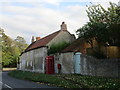
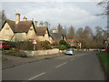
Cottages, South Rauceby
The earliest parts may date from the eighteenth century but there have been many alterations and additions since.
The telephone box is listed https://www.britishlistedbuildings.co.uk/101260868-k6-kiosk-oppposite-number-34-south-rauceby#.WezXJ4hrzVI
Image: © Jonathan Thacker
Taken: 20 Oct 2017
0.11 miles
4
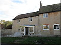
Sawyer's House, South Rauceby
A converted barn https://www.britishlistedbuildings.co.uk/101168507-sawyers-house-south-rauceby#.WezTB4hrzVI
Image: © Jonathan Thacker
Taken: 20 Oct 2017
0.11 miles
6
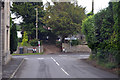
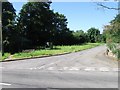
Junction of Tom Lane and Main Street, South Rauceby
Left for Sleaford, right for Grantham.
Image: © Julian P Guffogg
Taken: 14 Jun 2015
0.12 miles
8
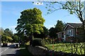
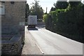
South Rauceby
Looking east along Main Street
Image: © Bob Harvey
Taken: 6 Oct 2017
0.12 miles
9

Former Telephone Exchange, South Rauceby
Situated in Main Street NG34 8QQ, this building was a former TE dating from the GPO era, but is now a garage. The new TE is a short distance away https://www.geograph.org.uk/photo/6441302 refers.
Image: © David Hillas
Taken: 19 Jul 2019
0.12 miles
10
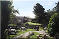
Beer Garden
A pleasant place to sit in the afternoon, outside the Bustard Inn
Image: © Bob Harvey
Taken: 6 Oct 2017
0.12 miles