IMAGES TAKEN NEAR TO
Grantham Road, SLEAFORD, NG34 8PW
Introduction
This page details the photographs taken nearby to Grantham Road, NG34 8PW by members of the Geograph project.
The Geograph project started in 2005 with the aim of publishing, organising and preserving representative images for every square kilometre of Great Britain, Ireland and the Isle of Man.

There are currently over 7.5m images from over14,400 individuals and you can help contribute to the project by visiting https://www.geograph.org.uk
Image Map
Images are licensed for reuse under creativecommons.org/licenses/by-sa/2.0
Notes
- Clicking on the map will re-center to the selected point.
- The higher the marker number, the further away the image location is from the centre of the postcode.
Image Listing (24 Images Found)
Images are licensed for reuse under creativecommons.org/licenses/by-sa/2.0
Image
Details
Distance
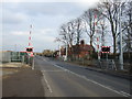
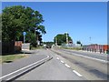
1
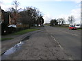
Level Crossing
This level crossing just west of Sleaford carries the A153 over the Sleaford to Nottingham line.
Image: © Michael Patterson
Taken: 15 Feb 2006
0.02 miles
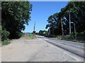
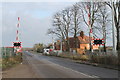
2
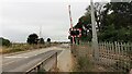
Quarrington Level Crossing for Grantham Road (A153) across railway
Image: © Roger Templeman
Taken: 27 Jun 2023
0.03 miles
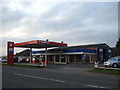
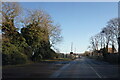
4
Greylees Garage
Greylees is the name given to a housing development on the site of the former Rauceby Hospital.
Image: © Jonathan Thacker
Taken: 2 Mar 2017
0.03 miles
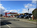
8
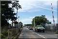
Level crossing over A153 (Grantham Road)
Image: © David Smith
Taken: 18 Sep 2018
0.05 miles
10
Level Crossing on the A153
On the Sleaford to Nottingham Line.
Image: © J.Hannan-Briggs
Taken: 13 Jan 2013
0.05 miles