IMAGES TAKEN NEAR TO
South Rauceby, SLEAFORD, NG34 8PU
Introduction
This page details the photographs taken nearby to NG34 8PU by members of the Geograph project.
The Geograph project started in 2005 with the aim of publishing, organising and preserving representative images for every square kilometre of Great Britain, Ireland and the Isle of Man.

There are currently over 7.5m images from over14,400 individuals and you can help contribute to the project by visiting https://www.geograph.org.uk
Image Map
Images are licensed for reuse under creativecommons.org/licenses/by-sa/2.0
Notes
- Clicking on the map will re-center to the selected point.
- The higher the marker number, the further away the image location is from the centre of the postcode.
Image Listing (3 Images Found)
Images are licensed for reuse under creativecommons.org/licenses/by-sa/2.0
Image
Details
Distance
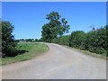
1
South Rauceby Lodge
Long view to South Rauceby Lodge
Image: © Richard Croft
Taken: 24 Oct 2011
0.04 miles
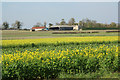
2
Barley field off Thorpe Drove
Looking towards South Rauceby Lodge.
Image: © Jonathan Thacker
Taken: 13 Jul 2019
0.19 miles