IMAGES TAKEN NEAR TO
Farriers Gate, SLEAFORD, NG34 8NT
Introduction
This page details the photographs taken nearby to Farriers Gate, NG34 8NT by members of the Geograph project.
The Geograph project started in 2005 with the aim of publishing, organising and preserving representative images for every square kilometre of Great Britain, Ireland and the Isle of Man.

There are currently over 7.5m images from over14,400 individuals and you can help contribute to the project by visiting https://www.geograph.org.uk
Image Map
Images are licensed for reuse under creativecommons.org/licenses/by-sa/2.0
Notes
- Clicking on the map will re-center to the selected point.
- The higher the marker number, the further away the image location is from the centre of the postcode.
Image Listing (50 Images Found)
Images are licensed for reuse under creativecommons.org/licenses/by-sa/2.0
Image
Details
Distance
1
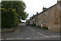
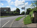
Street in Cranwell village
Behind the Post Office.
Image: © Chris
Taken: 8 Jun 2013
0.03 miles
3
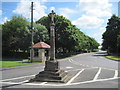
Medieval village cross Cranwell
Restored in 1903-4 by C. H. Fowler. The churchyard can be seen in the trees behind the bus shelter.
Image: © Martin Dawes
Taken: 16 Jun 2013
0.05 miles
4
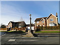
Old Preaching Cross (restored) at Cranwell
Image: © Adrian S Pye
Taken: 19 Nov 2017
0.05 miles

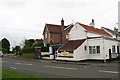
7
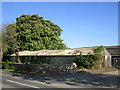
Shed at Manor Farm, Cranwell
Judging by the undulating roofline this building is on the way to collapsing.
Image: © Jonathan Thacker
Taken: 14 May 2019
0.06 miles
8
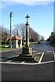
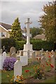
Cranwell Cross
Restored ancient cross by St.Andrew's church at Cranwell
Image: © Richard Croft
Taken: 3 Feb 2008
0.06 miles
9
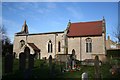
St.Andrew's church
View from the south east
Image: © Richard Croft
Taken: 3 Feb 2008
0.06 miles
10
The Graveyard of St Andrews Church, Cranwell.
Image: © gary radford
Taken: 4 Oct 2009
0.07 miles