IMAGES TAKEN NEAR TO
Roxholm, SLEAFORD, NG34 8ND
Introduction
This page details the photographs taken nearby to NG34 8ND by members of the Geograph project.
The Geograph project started in 2005 with the aim of publishing, organising and preserving representative images for every square kilometre of Great Britain, Ireland and the Isle of Man.

There are currently over 7.5m images from over14,400 individuals and you can help contribute to the project by visiting https://www.geograph.org.uk
Image Map
Images are licensed for reuse under creativecommons.org/licenses/by-sa/2.0
Notes
- Clicking on the map will re-center to the selected point.
- The higher the marker number, the further away the image location is from the centre of the postcode.
Image Listing (4 Images Found)
Images are licensed for reuse under creativecommons.org/licenses/by-sa/2.0
Image
Details
Distance
1
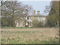
Roxholm Hall
This Hall is used as a care centre.
Image: © David Hurn
Taken: 30 Mar 2007
0.10 miles
2
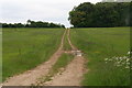
Farm track at Roxholme
The material heaped by the side of the track is barley that has been grown for forage. Presumably this was a loading point.
Image: © Jonathan Thacker
Taken: 24 Jun 2019
0.14 miles
3
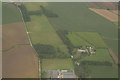
Remains of ridge and furrow near Roxholme Hall: aerial 2020
Image: © Chris
Taken: 30 Aug 2020
0.25 miles