IMAGES TAKEN NEAR TO
Manor Close, SLEAFORD, NG34 8LW
Introduction
This page details the photographs taken nearby to Manor Close, NG34 8LW by members of the Geograph project.
The Geograph project started in 2005 with the aim of publishing, organising and preserving representative images for every square kilometre of Great Britain, Ireland and the Isle of Man.

There are currently over 7.5m images from over14,400 individuals and you can help contribute to the project by visiting https://www.geograph.org.uk
Image Map
Images are licensed for reuse under creativecommons.org/licenses/by-sa/2.0
Notes
- Clicking on the map will re-center to the selected point.
- The higher the marker number, the further away the image location is from the centre of the postcode.
Image Listing (6 Images Found)
Images are licensed for reuse under creativecommons.org/licenses/by-sa/2.0
Image
Details
Distance


3
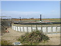
Sewage Farm, Meadow Lane, Leasingham.
The Sewage Works is at the end of the lane.
Image: © David Hurn
Taken: 17 Mar 2007
0.23 miles
4
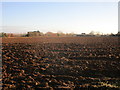
Ploughed field on the edge of Leasingham
Image: © Jonathan Thacker
Taken: 3 Dec 2019
0.24 miles
5
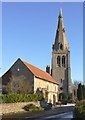
Hall Farm and Leasingham church
With snow on the ground in December 2009. The house dates from the 18th century is Listed grade II.
Image: © Alan Murray-Rust
Taken: 20 Dec 2009
0.25 miles
6
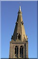
Leasingham church spire
A fine 14th century broach spire with alternating lucarnes, in fine-dressed ashlar.
Image: © Alan Murray-Rust
Taken: 20 Dec 2009
0.25 miles